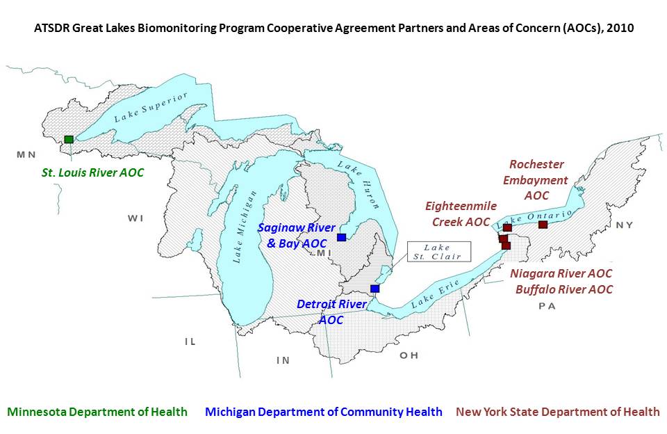
3a - State Coop Agreement Study Areas
Att3a_State_Cprtv_Agrmnt_Prtnrs_20120619.docx
Biomonitoring of Great Lakes Populations Program
3a - State Coop Agreement Study Areas
OMB: 0923-0044
Attachment 3. Program Overview
Attachment 3a. State Cooperative Agreement Programs and Study Areas

Michigan Department of Community Health
The boundaries of the Saginaw River/Bay Area of Concern (AOC) includes the entire 22 mile (35 km) length of the Saginaw River and all of Saginaw Bay (1,143 square miles or 2,960 square kilometers) out into its interface with open Lake Huron at an imaginary line drawn between Au Sable Point and Point Aux Barques. Over half of the land use in the region is agricultural. The primary urban and industrial centers are Flint, Saginaw, Bay City and Midland. See http://www.epa.gov/glnpo/aoc/sagrivr.html.
The Detroit River is a 32-mile international connecting channel linking Lake St. Clair and the upper Great Lakes to Lake Erie. The Detroit River Area of Concern (AOC) is a binational AOC which drains approximately 700 square miles of land in Michigan and Ontario, as well as the 107 square mile City of Detroit “sewershed.” Approximately 75 percent of the total land area of the watershed is in Michigan (607.7 square miles). See http://www.epa.gov/glnpo/aoc/detroit.html.
Minnesota Department of Health
The St. Louis River, the largest U.S. tributary to Lake Superior, drains 3,634 square miles, entering the southwestern corner of the lake between Duluth, Minnesota and Superior, Wisconsin. The St. Louis River System Area of Concern (AOC) is the area being addressed by the St. Louis River System Remedial Action Plan (RAP). While system-wide in its approach, the St. Louis River AOC focuses primarily on the lower 39 river miles and the entire 360 square mile Nemadji River watershed. The Nemadji River is split almost equally between Minnesota and Wisconsin and discharges into the Duluth-Superior Harbor near the natural outlet of the St. Louis River. See http://www.epa.gov/glnpo/aoc/stlouis.html.
New York State Department of Health
The Buffalo River Area of Concern (AOC) is located in the City of Buffalo in Western New York State. The river flows from the east and discharges into Lake Erie near the head of the Niagara River. The Buffalo River Area of Concern “impact area” extends from the mouth of the Buffalo River to the farthest point upstream at which the backwater condition exists during Lake Erie’s highest monthly average lake level. The impact area is 6.2 miles (10 km) in length. The AOC also includes the entire 1.4-mile (2.3 km) stretch of the City Ship Canal, located adjacent to the river. The AOC impact area is characterized by historically heavy industrial development in the midst of a large municipality. Land use in the tributary watersheds primarily consists of residential communities, farmland, wooded areas and parks interspersed with commercial land use. The total drainage area for the Buffalo River watershed is approximately 440 square miles. See http://www.epa.gov/glnpo/aoc/buffalo.html.
The Niagara River Area of Concern (AOC) is located in Erie and Niagara counties in western New York. This AOC extends from Smokes Creek near the southern end of the Buffalo Harbor, north to the mouth of the Niagara River at Lake Ontario. Past municipal and industrial discharges and waste disposal sites have been a source of contaminants to the Niagara River. A long history of development has also changed the original shoreline along much of the river, affecting fish and wildlife habitat. Fish migration from Lake Ontario has an influence on the Niagara River community as does the related affects of invasive species. Metals and cyanides in the sediment prevent open lake disposal of bottom sediments dredged from the river. Sources and loadings of pollutant causing use impairments in the Niagara River include these sediments as well as inactive hazardous waste sites, combined sewer overflows, and other point and nonpoint sources. Contamination originating from discharges within Lake Erie's watershed contributes to effects in the Niagara River and Lake Ontario. These sources and river shoreline practices both contribute to the identification of use impairments for which remedial action is being taken to restore and protect beneficial uses. See http://www.epa.gov/glnpo/aoc/niagara.html.
The Eighteenmile Creek Area of Concern (AOC) is located in the Town of Newfane, Niagara County, in western New York State. The creek flows from the south and discharges through Olcott Harbor into Lake Ontario, approximately 18 miles east of the mouth of the Niagara River. The AOC includes Olcott Harbor at the mouth of the creek and extends upstream to the farthest point at which backwater conditions exist during Lake Ontario’s highest monthly average lake level. This point is located just downstream of the Burt Dam, approximately 2 miles south of Olcott Harbor. The Eighteenmile Creek watershed downstream of the Burt Dam is primarily composed of cropland, orchards and residential areas. Upstream of the Burt Dam, the watershed is composed mainly of cropland and orchards, with residential and commercial areas like the historically industrialized City of Lockport. See http://www.epa.gov/glnpo/aoc/eighteenmile.html.
The Rochester Embayment Area of Concern (AOC) is an area of formed by the indentation of the Monroe County (New York) shoreline between Bogus Point in the town of Parma and Nine Mile Point in the town of Webster, both in Monroe County. The northern boundary of the embayment is delineated by the straight line between these two points. The southern boundary includes approximately 9.6 km (6 miles) of the Genesee River that is influenced by lake levels, from the river's mouth to the Lower Falls. The drainage area of the embayment is more than 3,000 square miles (7,770 km2) in area. This area consists of the entire Genesee River Basin and parts of two other drainage basins; the easternmost area of the Lake Ontario West Basin and the westernmost area of the Lake Ontario Central Basin. See http://www.epa.gov/glnpo/aoc/rochester.html.
| File Type | application/vnd.openxmlformats-officedocument.wordprocessingml.document |
| Author | wdw0 |
| File Modified | 0000-00-00 |
| File Created | 2021-01-30 |
© 2026 OMB.report | Privacy Policy