D-2101: 2020 LUCA Information Guide Text
D-2101 2020 LUCA Information Guide Text_DRAFT_10_28_2016.docx
2020 Census Local Update of Census Addresses Operation (LUCA)
D-2101: 2020 LUCA Information Guide Text
OMB: 0607-0994
2020 Census Local Update of Census Addresses Operation (LUCA)
Information Guide
What is LUCA?
The Local Update of Census Addresses Operation (LUCA) is a voluntary decennial census operation. LUCA is the only opportunity prior to the 2020 Census for tribal, state, and local governments (including the District of Columbia and Puerto Rico) to review and update the Census Bureau’s residential address list for their jurisdiction. The Census Bureau relies on a complete and accurate address list to reach every living quarters and associated population for inclusion in the census. The Census Address List Improvement Act of 1994 (Public Law 103-430) authorizes LUCA.
Active, functioning, legal governments are eligible to participate in LUCA, including:
Federally recognized tribes with a reservation and/or off reservation trust lands;
States;
Counties;
Cities (incorporated places); and
Townships (minor civil divisions).
If your government lacks the resources to participate in LUCA, you can arrange for a higher level of government, such as county, or an organization, such as a regional planning agency or council of governments, to conduct your address review.
Why Participate in LUCA?
The accuracy and completeness of the address list is critical to the accuracy and completeness of the decennial census. Participating in LUCA can help ensure an accurate census for your community.
Although the primary purpose of the decennial census is to apportion seats in the U.S. House of Representatives, census data is used to:
Distribute federal funds for over 1,000 programs administered by 26 federal agencies to tribal, state and local governments;
Provide statistical support for grant applications that fund community and regional development, education, agriculture, energy, and environmental programs as well as other needed community improvements and enhancements; and
Help your community plan for future needs.
What is new for LUCA?
Pre-LUCA activities, such as the on-going Geographic Support System (GSS) Partnership Program, provide more opportunities to submit address information and receive non-Title 13, feedback;
New streamlined participation through the full address list review;
Online viewing availability for the Census Bureau housing unit counts by census block for your jurisdiction starting in January 2017;
Ease of use with standard data formats for viewing the Census Bureau’s digital address list (Excel (.xlsx) and Comma Delimited Text (.csv));
Availability of the Census Bureau Geographic Update Partnership Software (GUPS), a self-contained Geographic Information System (GIS) tool;
Access to comprehensive data that includes residential structure latitude/longitude coordinates and ungeocoded census residential addresses; and
Digital participants may submit residential structure coordinates as part of their address updates.
LUCA Schedule
January 2017
|
Advance notice mailed to Highest Elected Officials (HEOs), Tribal Chairs (TCs), Governors, and other LUCA contacts
|
March 2017
|
LUCA promotional workshops begin
|
July 2017
|
LUCA invitation and registration mailed to HEOs, TCs, and Governors
|
October 2017
|
LUCA training workshops begin
|
February-April 2018
|
Participants review and update the U.S. Census Bureau’s address list
|
February-September 2018
|
Census Bureau processes LUCA submissions
|
LUCA Preparation Checklist
Review your boundaries and respond to the 2017 Boundary and Annexation Survey (BAS)
Attend a LUCA promotional workshop or access information at the LUCA website
Access the Census Address Count List for your jurisdiction online
Unit designations for multiunit housing (Apt 1, Apt 2, Unit A, Unit B, etc.) (required);
Residential address status (required, the LUCA Operation only accepts residential addresses); and
ZIP Codes for (mailing) addresses (desired).
Geocode your local address list using the online Census Geocoder (digital address list required)
Highest Elected Official (HEO), Tribal Chair (TC), Governor registers for LUCA

 Pre-LUCA
activities
provide more opportunities to submit address information and receive
non-Title 13 feedback through the continuous GSS Partnership Program.
 The
2017 BAS is the last opportunity to ensure that your boundaries are
correct before LUCA begins. Because LUCA participants receive only
addresses inside their jurisdictional boundaries for review and
update, you may not be able to view your entire address list if your
boundaries are incorrect. The 2017 BAS starts in December 2016. For
more information, visit the BAS website at
<www.census.gov/geo/partnerships/bas.html>.
 In
January 2017, the HEO, TC, Governor, and other contacts that the
Census Bureau has associated with each government will receive a LUCA
notification package. The package includes information about LUCA and
a Contact
Information Update Form.
Complete the form and return it using the postage-paid envelope. If
you prefer, you may scan it and return it via email to
[email protected].
In
January 2017, the HEO, TC, Governor, and other contacts that the
Census Bureau has associated with each government will receive a LUCA
notification package. The package includes information about LUCA and
a Contact
Information Update Form.
Complete the form and return it using the postage-paid envelope. If
you prefer, you may scan it and return it via email to
[email protected].
 Plan
to attend a LUCA promotional workshop or webinar to obtain additional
information about participating in LUCA. You may also obtain
additional information by accessing the LUCA website at,
<www.census.gov/geo/partnerships/luca.html>.
Your government’s Address Count List, which contains the Census Bureau’s count of residential addresses for each census block within your jurisdiction, is available on the LUCA website. Compare the census counts to your counts to help focus your participation efforts. Each census block record is at least 12 characters in length and contains seven fields of information. <www.census.gov/geo/maps-data/data/geocoder.html>.
Digital Address Count List
Max character length |
Field name |
Description |
12 |
Entity ID |
Unique code assigned by the Census Bureau to each entity |
2 |
State Code |
2-digit current state code |
3 |
County Code |
3-digit current county code |
6 |
Census tract number |
6-digit current census tract number, with an implied decimal point between the fourth and fifth digit |
4 |
Census block number |
4-digit current census block number |
7 |
Count of housing unit addresses |
Census Bureau’s most recent count of housing unit addresses |
7 |
Count of group quarters addresses |
Census Bureau’s most recent count of group quarters addresses |

Potential local address sources for compiling your residential address list include:
E-911 address files;
New housing construction or building permits;
Housing inspection records;
Planning and zoning records;
Local utility records;
School enrollment records;
Driver license files;
Annexation records;
Assessment or tax files (residential units); and

Voter registration files.
Unit Designation: LUCA requires that each record include unit identifiers (e.g., Apt 1, Apt 2, Unit A, Unit B). Basic street address and the individual unit designation should be provided for multiunit buildings.
Residential Status: LUCA accepts only residential address updates.
ZIP Code: A ZIP Code in a mailing address is useful to the Census Bureau.

The Census Bureau defines geocoding as assigning a state, county, census tract, and census block number to an address. Used in conjunction with the Address Count List, the Census Geocoder allows you to compare your digital address list to the Census Bureau’s count of addresses by census block. You can focus your address review on the census blocks with the greatest address count differences between your address list and the Census Bureau’s. For more information, see <www.census.gov/geo/maps-data/data/geocoder.html>.

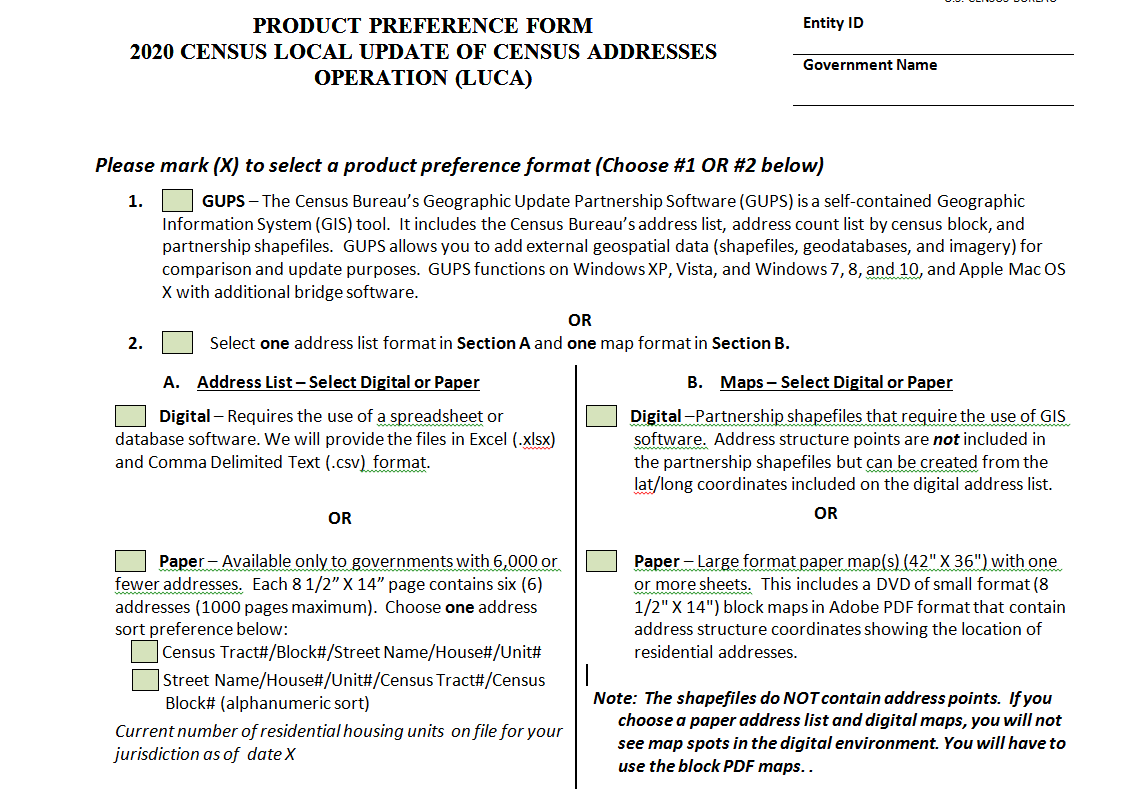
The LUCA address lists and maps are available in digital or paper formats. The digital format requires the use of spreadsheet or database software such as Excel (.xlsx) or Comma Delimited Text (.csv). The paper format is available only to governments with 6,000 or fewer addresses.
Example: Available LUCA materials formats
Copy provided for reference only; do NOT return this form

To conduct your address review, consider your time, staff, and available local address information. If a complete review is not possible, focus your review on these areas:
Group Quarters (e.g., housing such as college dorms, and nursing homes);
Areas of new construction;
E-911 address conversion areas;
Single-family homes converted to multifamily homes, and vice versa;
Warehouses converted to residential units;
New mobile homes;
Apartment buildings with irregular or missing numbering schemes for the individual units;
Annexed land;
Areas along governmental boundaries; and

Blocks with the greatest count differences between the Census Bureau’s address block count and your address block count.
In July 2017, the Census Bureau will mail the invitation letter and registration form to your HEO, TC or Governor. This invitation package will include information about LUCA and a registration form for the HEO, TC, Governor, and the LUCA liaison (designated by the HEO, TC or Governor) to complete and return to the Census Bureau for participation in LUCA.

 Training
workshops will offer “hands-on” experience using the LUCA
materials. Self-training aids and webinars will be available online
at the LUCA website. In addition, the 2020
Census Local Update of Census Addresses Operation (LUCA) Respondent
Guide
contains detailed instructions and examples for conducting your
address and map review.
 You
have 120
calendar days from
the receipt of your materials to conduct your address review and
return your updates to the Census Bureau. We estimate that it will
take between 16 to 672 hours to complete your address review and
submit your updates, depending on your jurisdiction’s size and
number of changes.
After validating LUCA submissions, the Census Bureau will provide address feedback on your LUCA updates.
![]() Questions
Questions
For more information about LUCA call 1-844-344-0169, email us at [email protected], or visit us on the website at <www.census.gov/geo/partnerships/luca.html>.
Digital Address List Record Layout
The information contained on each census address record includes census state and county codes, census tract and block numbers, and group quarters flag. The character length for each record may vary.
Max Character Length |
Field Name |
Description |
7 |
Line Number |
Sequential number for each address record in the file |
9 |
MAFID |
Unique control number assigned to each MAF address |
12 |
Entity ID Code |
Unique number assigned by the Census Bureau to each entity |
1 |
Action Code |
Entered by the participant to indicate an action to be taken on the address |
2 |
State Code |
2-digit current state code |
3 |
County Code |
3-digit current county code |
6 |
Census Tract Number |
6-digit current census tract number, with an implied decimal point between the fourth and fifth digit (e.g., 123401 and 000300) |
4 |
Census Block Number |
4-digit Census Block Number |
15 |
GEO ID |
15-digit combination of state code, county code, census tract and census block numbers |
1 |
Group Quarters Flag |
Displays a ‘y’ if the address is a group quarters |
35 |
Complete Address Number |
Housing unit or group quarter's assigned address number, alone or with an address number prefix and/or address number suffix, that identifies a location along a thoroughfare or within a community |
100 |
Complete Street Name |
Full street or road name The official name of a thoroughfare as assigned by a governing authority, or an alternate (alias) name that is used and recognized |
65 |
Apartment/Unit Number |
Within structure descriptor or identifier, such as APT 5 or 1st FL FRN |
5 |
City-Style Mailing ZIP Code |
5-digit ZIP Code for city-style mailing address |
100 |
Group Quarters Name |
Name of group quarter (e.g., Dobbs Hall) |
100 |
Facility Name |
Name of group quarter facility (e.g., University of Illinois) |
100 |
Location Description |
Description of the location and physical characteristics of a living quarters (e.g., red ranch with white shutters) |
50 |
Noncity-Style Mail Delivery Address (RR#, HCR#, or PO Box #) |
Rural Route and Box number, Highway Contract Route number, or Post Office Box number |
5 |
Noncity-Style Mailing ZIP Code |
5-digit ZIP Code for noncity-style mailing address |
4 |
Map Spot ID |
Unique number assigned by the Census Bureau for each map spot within a block. Numbering starts over in each block |
1 |
Address Use |
A value entered by the participant indicating if the address is used for M) mailing purposes, L) location purposes, including emergency services, B) both mailing and location purposes |
11 |
Structure Latitude |
Address structure latitude, populated only if the Census Bureau has captured an address structure point for the address, otherwise blank. If blank, participants can populate this field |
12 |
Structure Longitude |
Address structure longitude, populated only if the Census Bureau has captured an address structure point for the address, otherwise blank. If blank, participants can populate this field |
1 |
City-Style Address Flag |
Displays “y” if city-style address, “n” if noncity-style address |
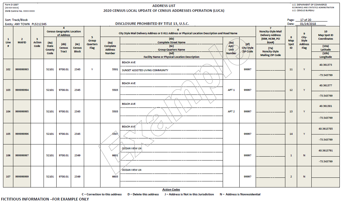
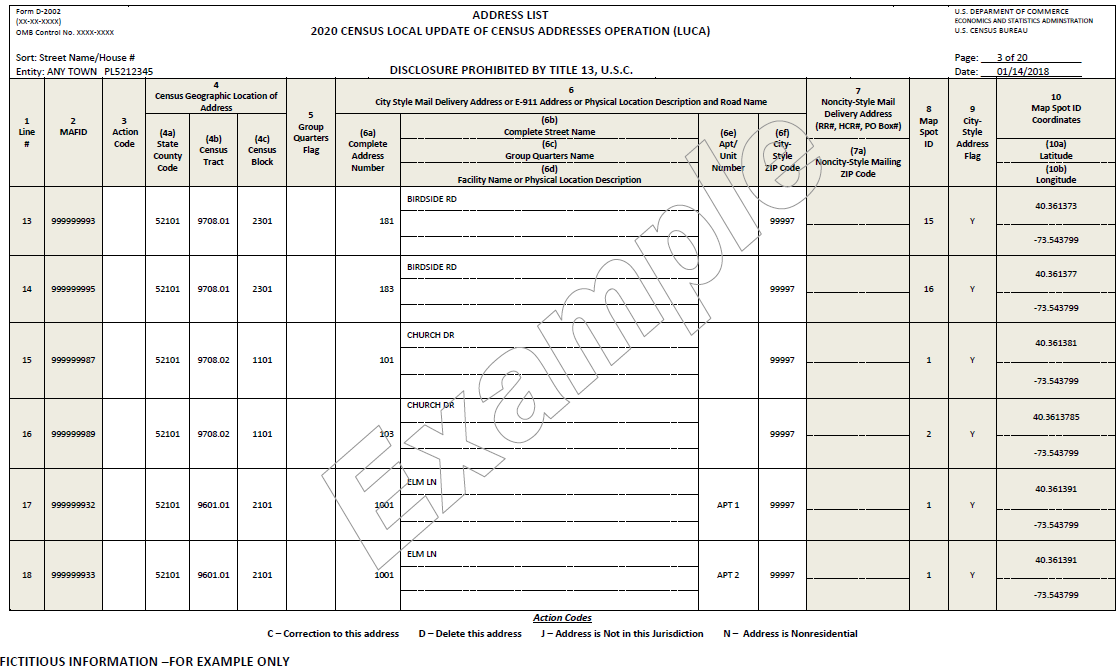
Paper Address List
The information contained in the paper address list includes state and county codes, census tract and block numbers, address information, and group quarters flag. The paper address list is available only to governments with 6,000 or fewer addresses. Each 8 1/2” X 14” page contains six addresses (1000 pages maximum). You may choose one of two sort preferences: Census Tract#/Block#/Street Name/House#/Unit# or Street Name/House #/Unit#/Census Tract#/ Census Block#
Example sort: Census Tract/Block
Example sort: Street Name/House#/Unit#/Census Tract#/Census Block#
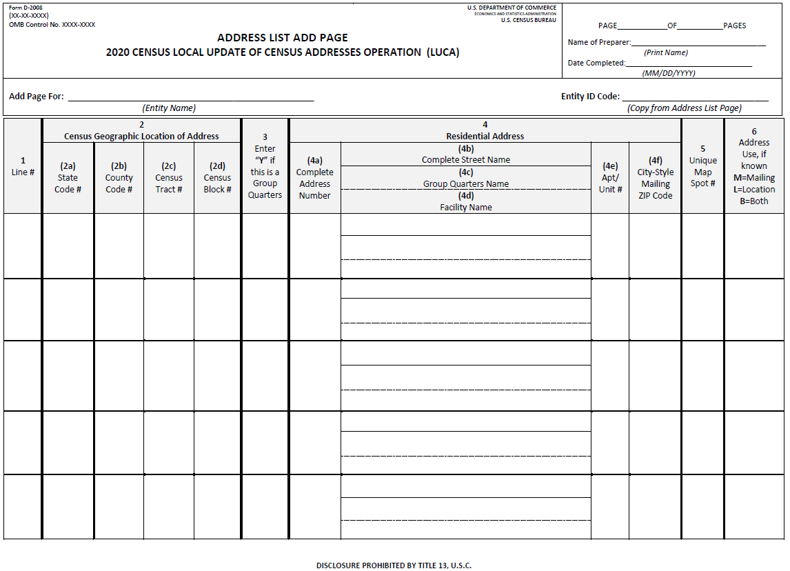
Paper Address List Add Page
Participants selecting the paper address list can add residential city-style addresses that do not appear on the Census Bureau’s address list using the Address List Add Page.
Example: Address List Add Page
Paper Address Count List
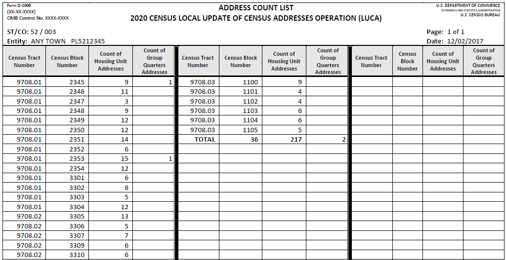
The LUCA address count list contains the count of housing unit and group quarters addresses for each census block within your jurisdiction. The list contains 90 census blocks per page. This list is for reference only.
Example: Address Count List

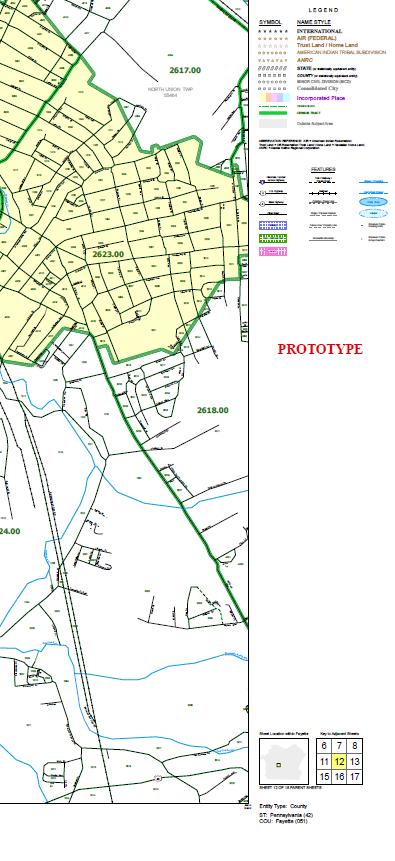
Example: Paper Map
Census
Bureau Paper Maps and Digital Shapefiles Paper—Large
format paper map(s) (42" X 36") with one or more sheets.
This includes a DVD of small format (8 1/2" X 14") block
maps in Adobe PDF format that contain address structure coordinates
showing the location of residential addresses. Digital—Topologically
Integrated
Geographic
Encoding
and Referencing
(TIGER)
Partnership shapefiles that require the use of Geographic
Information System (GIS) software. Address structure points are not
included
in the partnership shapefiles but can be created from the latitude
/longitude coordinates included on the digital address list.
| File Type | application/vnd.openxmlformats-officedocument.wordprocessingml.document |
| Author | Rebecca S Swartz |
| File Modified | 0000-00-00 |
| File Created | 2021-01-15 |
© 2026 OMB.report | Privacy Policy