Residue & Biomass Field Survey - Generic Testing
0248-Residue Survey - Generic Testing - 2012.docx
Generic Clearance of Survey Improvement Projects
Residue & Biomass Field Survey - Generic Testing
OMB: 0535-0248
Residue and Biomass Field Survey, Generic Testing - OMB No. 0535-0248
Overview
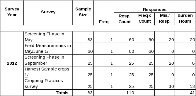
NASS is submitting three new Information Collection Instruments to the Generic Testing Docket (0535-0248) for a proposed Residue and Biomass Field Survey. NASS and Agricultural Research Service (ARS)/Hydrology and Remote Sensing Laboratory (HRSL) plan to contact approximately 83 crop farm operators in May. We are anticipating that about 60 operators will sign the screening form in May to allow HRSL to enter their fields and take digital photographs of crop residue and collect small soil and crop residue samples. In September, a subsample of approximately 25 operations will be contacted asking them to complete a second permission form. This form will allow NASS to harvest several complete plants from the target fields to measure organic matter produced along with grain produced. Finally, in December these same 25 operators will be contacted again to collect cropping practices on the fields that were being monitored for this test.
Purpose of Test
The purpose of this test is to see if NASS can make an objective connection between the amount of organic matter produced and how crop residues impact future crop yields. Ultimately, NASS wants to test if the measurements of crop residues and crop biomass can be used to assess what the effects of crop residue removal, for biofuel production, will have on the soil and water quality.
Detailed Information
There will be one permission form that will be presented to 83 operators in May by NASDA enumerators prior to HRSL entering the operator’s field, with the assumption of receiving approximately 60 signed permission slips. The target sample (60 crop farmers) will have various measurements for crop residues. Crop residue cover will be estimated by a team of 2-3 people from HRSL who will walk to two locations within a field, stretch a 50-foot line with 100 beads, and count the number of beads intersecting pieces of crop residue. We also record field conditions and take photographs. Multispectral and hyperspectral remotely sensed data will be acquired and analyzed to map crop residue cover and soil tillage intensity for the entire watershed. Accuracy of the remotely sensed maps of crop residue cover and soil tillage intensity will be assessed using the measured crop residue cover data.
The second permission form will be presented to a subsample of 25 operators in September by NASDA enumerators prior to entering the operator’s field. After physiological maturity but before harvest, we will sample above-ground biomass and grain in selected corn fields. At two locations in each field, HRSL will cut, bag, and dry 6 corn plants. The corn grain and stover will be weighed separately. Harvest index, the ratio grain weight to total above ground plant weight, will be calculated. Harvest index data and yield maps, supplied by the producers, will be used to estimate the spatial distribution of the amount of crop residue per acre. Remotely sensed estimates of crop residue cover will be used to track the fate of crop residue and determine how much residue has been tilled into the soil or removed for biofuel.
The same 25 operators will be visited again in December and asked to complete a questionnaire and, if possible, provide a yield map.
In this pilot test we will be contacting corn growers in one watershed in Iowa.
Testing will be conducted exclusively by personal interview on a paper questionnaire. The test will involve approximately 41 total hours of respondent burden.
Initial contact, permission forms, and the December questionnaire will be conducted by NASDA Field Enumerators. Field sample and data collection will be conducted by HRSL personnel. Visits will be conducted at various times during May, September, and December. The test sample consists of fields in the South Fork watershed in central Iowa (Buckeye, IA). This allows the data and models for soil and water quality to be tested before any possible expansion.
The questionnaire that will be tested along with the two permission forms have been loaded into the ROCIS submission system.
Burden Calculations

1/ The operator does not need to be present for the field visits as described above.
| File Type | application/vnd.openxmlformats-officedocument.wordprocessingml.document |
| Author | HancDa |
| File Modified | 0000-00-00 |
| File Created | 2021-01-30 |
© 2026 OMB.report | Privacy Policy