Mini-Supporting Statement for Generic Testing - June Area Survey
0248 - Mini - Supporting Statement A and B for June Area Mobile Testing 2016 - 04-28-2016.docx
Generic Clearance of Survey Improvement Projects
Mini-Supporting Statement for Generic Testing - June Area Survey
OMB: 0535-0248
SUPPORTING STATEMENT
Generic Testing – June Area Survey
OMB No. 0535-0248
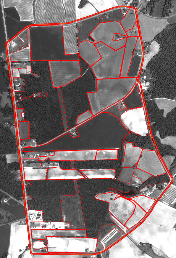
This mini-supporting statement is being submitted to OMB to define the need for conducting the 2016 June Area Testing. The test will consist of providing June Area Survey (JAS) enumerators with JAS segments containing pre-delineated field boundaries. Farm Service Agency (FSA) Common Land Unit (CLU) polygons will be intersected with the JAS segments. Because FSA CLUs do not provide 100% coverage of all JAS segments, NASS cartographers will pre-delineate the non-FSA covered areas using available topology, road maps and imagery from the National Agricultural Imagery Program (NAIP) among other sources. The final product delivered to enumerators will be a segment with pre-delineated field boundaries (See attached image). However, enumerators will not be able to tell the difference between a cartographer’s delineation and an FSA delineation. This process will be implemented in 40 segments, 20 each in North Carolina (NC) and Indiana (IN). Enumerators will be visiting segments that have never been in the JAS sample before.
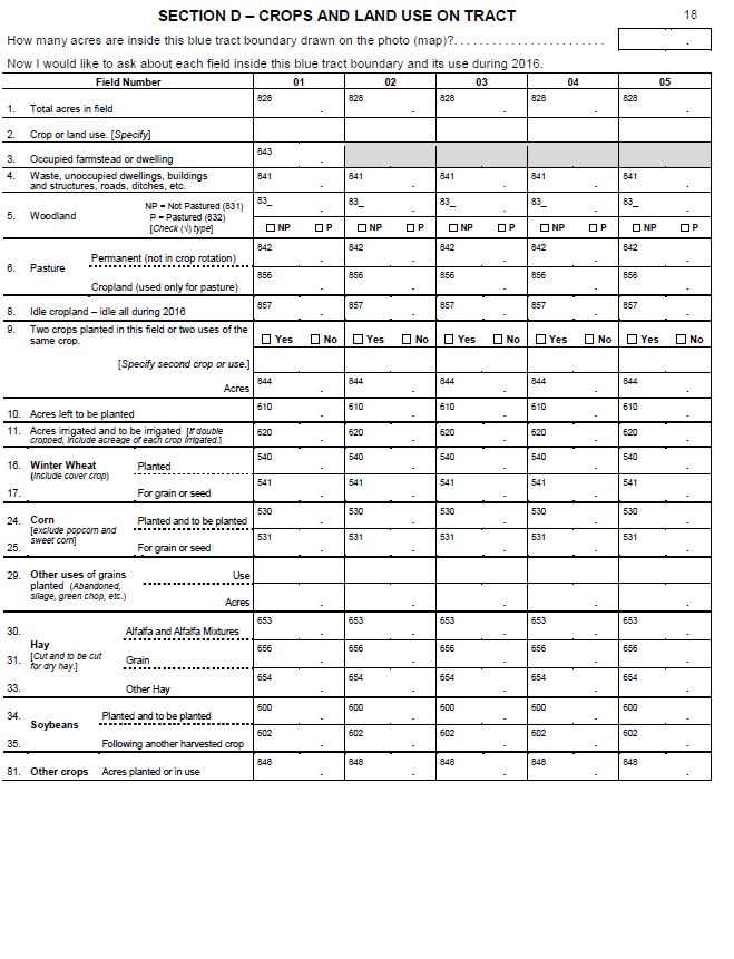
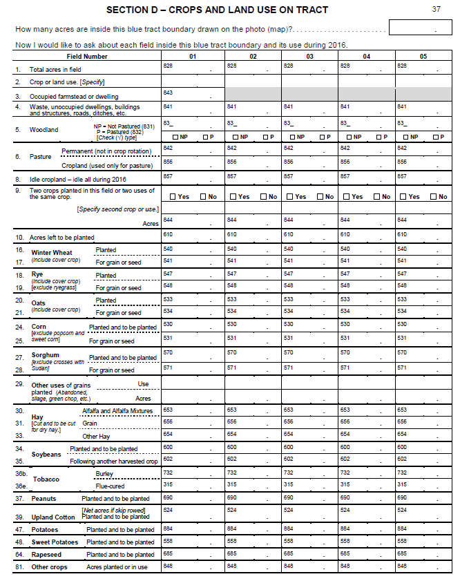
In our current JAS, enumerators are provided a paper aerial photo with the sampled segment area outlined in red. Enumerators divide the segment into separate tracts of land that represent each unique operating arrangement. Tracts are screened for agricultural activity and agricultural tract operators are asked general questions about their entire farming operation. In addition, specific details are collected about all fields that fall within the segment boundary. This is recorded in Section D of the paper questionnaire (attached).
In 2014, NASS evaluated collecting just the Section D data on grid segments using a mobile mapping instrument. The test proposed in 2016 will utilize an enhanced version of the mobile mapping instrument. This time enumerators will be provided digital imagery that contains pre-delineated field boundaries in addition to the segment outline. They will adjust field boundaries as needed during the interview with the farm operator. Enumerators will measure interview time and provide feedback on the usability and features of the enhanced mobile mapping instrument.
A. JUSTIFICATION
Circumstances making collection of information necessary.
NASS is developing a computer-assisted personal interviewing (CAPI) mobile mapping data collection instrument that is deployed on an iPad. Instead of simply recreating the June Area Survey as an electronic photo and questionnaire, the iPad makes it possible for NASS to develop a Geographic Information System (GIS) tool that can provide a vast improvement to the current JAS procedures. The mobile mapping instrument was developed with the Center for Survey Statistics and Methodology at Iowa State and will be the application tested to draw out farm segments and collect information about the land.
How, by whom, and for what purpose information is to be used.
The information gathered through field testing the mobile mapping instrument on the iPad will be used by our Area Frame Modernization Research Team (AFMRT) to identify and address issues related to full implementation such as connectivity, battery power, hardware and software issues, iPad visibility in bright conditions, questionnaire usability, ease of drawing tracts and fields, enumerator training, and any other potential technical problems.
The information gathered through these interviews will be analyzed by NASS’s Research and Development Division, Survey Administration Branch, and Summary, Estimation, and Disclosure Methodology Branch to see if additional modifications need to be made to the questionnaire, Interviewer’s Manual, editing parameters, internet data collection instrument, etc. Approved changes will be implemented into future testing that will be conducted in 2017.
Use of improved information technology.
The purpose of field testing the mobile mapping instrument on the iPad is to increase our use of improved information technology. The JAS is currently conducted using paper questionnaires and aerial photos of land segments. The mobile mapping application provides web GIS functionality including a mapping library to add layers to the imagery and tools to assist in drawing segments such as zoom, selection options, and undo/redo buttons. The iPad allows for imagery to be seen in color plus the benefits of having a computer assisted instrument platform in the field. The data will be collected by trained enumerators through face to face interviews.
4. Efforts to identify duplication.
No additional efforts will be taken to identify duplication. The mobile mapping instrument was specifically developed to collect the information about the land within the JAS segments.
Methods to minimize burden of small businesses.
The 40 JAS segments will be drawn to represent the various farm types in each of these States. We will be interviewing different size farm operators.
Consequence if information collection were less frequent.
This test is a critical step to identify issues related to, and feasibility of, full implementation of the technology.
Special circumstances.
There are no special circumstances associated with this information collection.
Federal register notice and consultation with outside persons.
Not applicable.
Payments or gifts to respondents.
There are no payments or gifts to respondents.
Confidentiality provided to respondents.
The same confidentiality that is applied to the 2016 JAS will be applied to data collected during the mobile mapping field test.
Questions of a sensitive nature.
There are no questions of a sensitive nature.
12. Hour burden and annualized costs to respondents.
The test is scheduled to be conducted in 40 total (20 per state) selected JAS segments in NC and IN.

Cost to the public of completing a questionnaire is assumed to be comparable to the hourly rate of those requesting the data. Reporting time of 52 hours is multiplied by $25 per hour for a total cost to the public of $1,300.
NASS regularly checks the Bureau of Labor Statistics’ Occupational Employment Statistics (Published March 30, 2016). Mean wage rates for bookkeepers, farm managers, and farm supervisors are averaged to obtain the wage for the burden cost. The May 2015 mean wage for bookkeepers is $18.74. The mean wage for farm managers is $33.60. The mean wage for farm supervisors is $23.22. The mean wage of the three is $25.19.
Total annual cost burden to respondents.
There are no capital/start-up or ongoing operation/maintenance costs associated with this information collection.
Annualized costs to federal government.
Costs for conducting the test interviews are estimated at $18,000. This will cover expenses for staff payroll, travel, survey training, and any other data collection expenses. Test development, and the analysis of data collected are estimated to cost approximately $7,000 for a total expense of $25,000. NASS and NASDA employees that have been trained to conduct interviews will travel to the farm operations in the 2 selected states to conduct the surveys.
Reasons for changes in burden.
This supporting statement addresses additional field tests that were not included in the Agricultural Surveys docket 0535-0213.
Tabulation, analysis, and publication plans.
No data will be published from these tests. Data are for internal use only.
Request for approval of non-display of expiration date.
There is no request for approval of non-display of the expiration date.
18. Exceptions to certification statement.
There are no exceptions to the certification statement.
B. COLLECTION OF INFORMATION EMPLOYING STATISTICAL METHODS:
Respondent’s universe, sampling and response rate.
NASS selected North Carolina and Indiana to be representative of the varying types of agriculture, farming operations, topography, cropping practices and crops from across the majority of the United States. We will be selecting 20 JAS segments from each State to represent the variety of conditions within each State. We are expecting an 80% response rate for these tests. Within each of the segments we will attempt to collect data from each respondent who operates or owns land inside the segment. We will follow the same data collection procedures used to conduct our June Area Surveys (0535-0213).
Procedures for the collection of information.
Trained NASDA enumerators and Supervisors will employ standard data collection procedures during these tests. We want to measure any variances that may occur from our normal June Area Survey conducted annually.
Information collected adequate for intended uses.
Not applicable.
Test of procedures or methods.
Not applicable.
Individuals consulted on statistical aspects of survey.
Denise Abreu, (703) 877-8044 Ext. 156, the lead of the Area Frame Modernization Research Team and a Mathematical Statistician in the Research and Development Division. Denise will be the lead contact on this test.
April 2016
ATTACHMENT
(Sample Area Segment)

A-1
Indiana

A-2
North Carolina
 A-3
A-3
| File Type | application/vnd.openxmlformats-officedocument.wordprocessingml.document |
| Author | HancDa |
| File Modified | 0000-00-00 |
| File Created | 2021-01-24 |
© 2026 OMB.report | Privacy Policy