Participant Input and Feedback to Improve Functionality and Design of ELAP Module
Generic Clearance for the Collection of Qualitative Feedback on Agency Service Delivery
ELAP User Guide for 3060-1149 (watermarked)
Participant Input and Feedback to Improve Functionality and Design of ELAP Module
OMB: 3060-1149

Eligible Locations Adjustment Process (ELAP) Module:
User Guide
Release 1.0 Participant Data Upload
TABLE OF CONTENTS
Contents
General Information and System Requirements 4
Certify Information in All Files 9
Location Data Upload Template 11
Data Error Codes for Location Data File 14
External Advanced Validations Data Issue Codes 25
FCC NOTICE REQUIRED BY THE PAPERWORK REDUCTION ACT
Estimate for work required is pending. If you have any comments on this estimate, or on how we can improve the collection and reduce the burden it causes you, please write the Federal Communications Commission, AMD-PERM, Paperwork Reduction Project (XXXX-XXXX), Washington, DC 20554. We will also accept your comments via the Internet if you send them to [email protected]. Please DO NOT SEND ANY ACCESS REQUESTS OR SUBMIT ANY DATA REQUIRED BY THIS COLLECTION TO THIS ADDRESS. You are not required to respond to a collection of information sponsored by the Federal government, and the government may not conduct or sponsor this collection, unless it displays a currently valid OMB control number or if we fail to provide you with this notice. This collection has been assigned an OMB control number of XXXXXXX.
THE FOREGOING NOTICE IS REQUIRED BY THE PAPERWORK REDUCTION ACT OF 1995, P.L. 104-13, OCTOBER 1, 1995, 44 U.S.C. 3507
General Information and System Requirements
Requirement |
Description |
Internet Browsers and Versions Supported |
|
User Access |
Carrier general counsels (GCs) and Support Operations Officers (SPOs) will be granted access to this system through our e-file system. Additional user access will be granted by the GC or SPO of the company. |
Concurrent Accounts |
Each organization may have an unlimited number of users. After six months of no usage, however, USAC will deactivate the unused user account. |
Session Timeout |
Sessions will timeout after 25 minutes of inactivity. You will receive a warning modal five minutes prior to the expiration of your session. |
 Participant
Manage Uploads
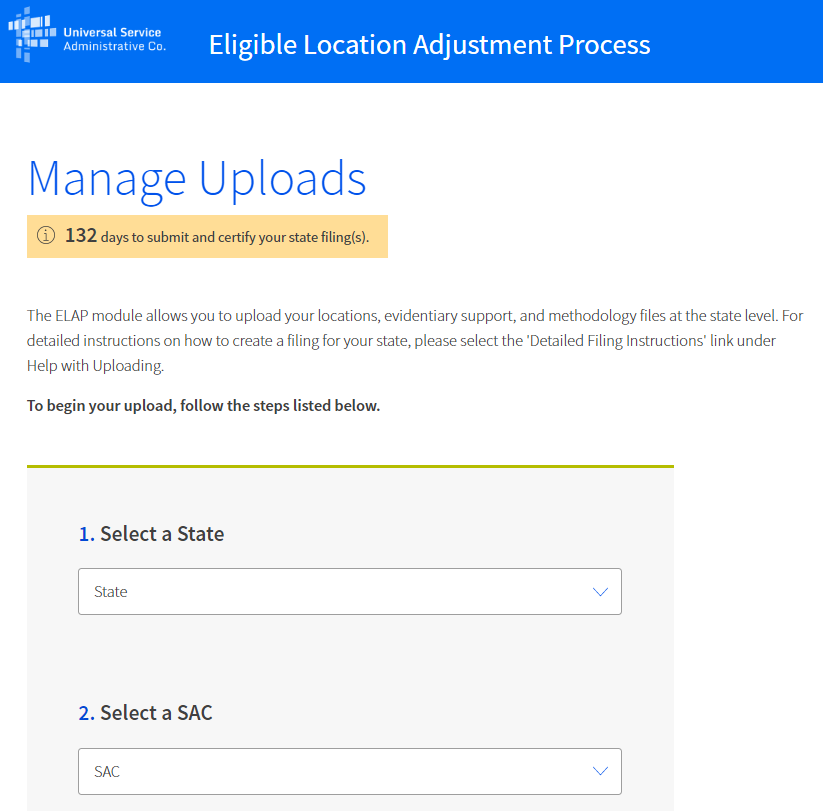
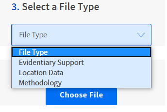
Participants must access the Manage Uploads Page to upload Location and other file types. The page has three sections: 1) Upload Data, 2) Uploaded Files Table, and 3) Certify Data. In the first section, Upload Data, you must identify the state and study area (by study area code (SAC)) for which you are uploading data by using the “select” drop down menu. For each state and SAC for which you are uploading data, you must provide at least one file of each type. There are three file types that must be uploaded: Evidentiary Support, Locations Data, and Methodology.
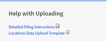
You must use the Locations Data Upload Template, LocationsDataUploadTemplate.csv, to upload Locations Data. The Template is available for download in the ‘Help with Uploading’ section on the right side of the Manage Uploads page. The Locations Data section of this guide provides definitions for the template fields and information on how to enter locations data, including formatting requirements.
The table below further describes the format and what each File Type must contain:
File Type (* = required) |
Minimum Data Submission Requirement |
Evidentiary |
|
Locations Data |
|
Methodology |
|
 Uploaded
Files
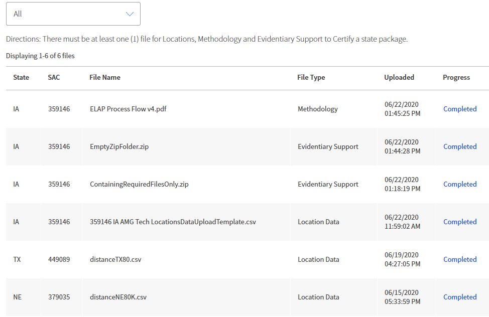
Once you have successfully uploaded a file you will see the file name appear in the Select a State table at the bottom of the page. You must upload one Locations file, one Methodology file, and at least one Evidentiary file for each SAC.
Depending on the file size and server availability, your file may take several minutes or longer to complete processing. You do not have to stay logged into the system to wait for your file(s) to complete processing. Once the upload process is completed, you can return later to view the results. If your file takes longer than two hours to complete processing, please alert USAC using the e-mail address: [email protected].
O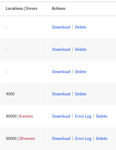 nce
your file(s) have completed processing you can see the overall
validation results and download a detailed log of any data errors
contained in the file. You can filter the table results by ‘State,’
by default the table displays all states for which you have uploaded
data. The ‘Locations|Errors’ column shows the number of
valid locations that were uploaded followed by the number of
validation errors, if any, that were detected. If your file contains
validation errors, you can download a log of these errors by
selecting the ‘Download’ link in the ‘Actions’
column on the far right of the table. Refer to the Data
Error Codes section of this
guide to troubleshoot locations data errors shown in the log.
Certify Information in All Files
T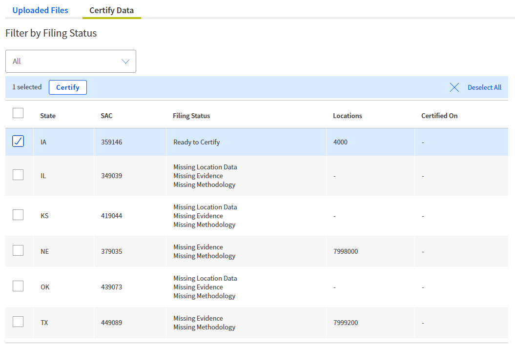 o
the right of the ‘Uploaded Files’ tab is the ‘Certify
Data’ tab. After you complete your file uploads, you should
select this tab. You will see a table organized by state and SAC
that detailing the ‘Filing Status’ for each SAC. When
you have uploaded the minimum number of files for a SAC and the files
have been verified, then the Filing Status will appear as ‘Ready
to Certify.’ SACs which are missing files will display which
file types are still required in the Filing Status column.
You may select one or more SACs to certify using the check box on in the right-hand column of the table. Once you have selected one or more SACs the ‘Certify’ button will be enabled. Once you have selected ‘Certify,’ you will see a modal appear titled Sign and Certify. You may complete certification for the SAC selected by typing your name in the signature box.
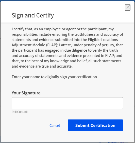
.
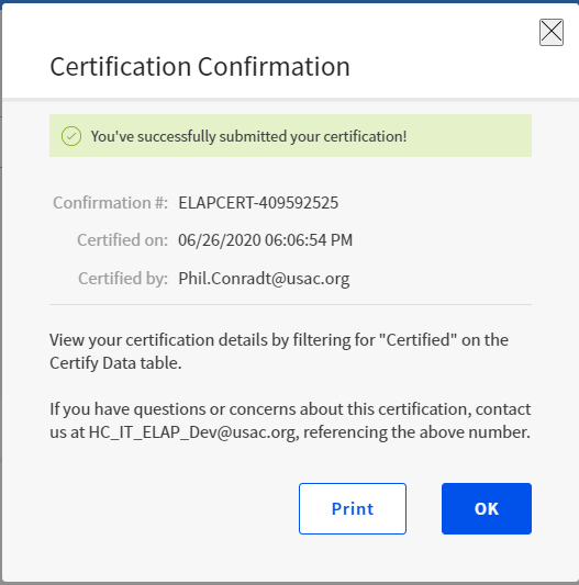
Once you sign the certification, a new Certification Confirmation module will provide you with a confirmation number, the date of certification, and the name of the certifying party. You will have the option to print this confirmation, which we recommend.
If, after receiving a Certification Confirmation number, you want to delete or add new files, you must revert the certification and re-certify all files being submitted.
Location Data Upload Template
The table below provides the specification for the Locations Data Upload Template CSV file.
Field (* = required) |
Description |
Data Type |
Max Length |
Example |
||||||||||||||||
Study Area Code* |
Study Area Code of the location. |
Integer |
6 |
123456 |
||||||||||||||||
Latitude* |
Latitude of the location. |
Float |
NA |
-12.123456 |
||||||||||||||||
Longitude |
Longitude of the location. |
Float |
NA |
-123.123456 |
||||||||||||||||
Location Distance Comment |
Identifies why a location is within 36 feet of another location. |
String |
100 |
Locations are attached townhouses… |
||||||||||||||||
Address* |
Number and street address of the location. |
String |
100 |
123 Elm Street |
||||||||||||||||
City* |
City associated with the street address of the location. |
String |
50 |
Richmond |
||||||||||||||||
State* |
The state or states for which the carrier is making a filing. |
String |
2 |
VA |
||||||||||||||||
Zip Code* |
5-digit ZIP code associated with the street address of the location. |
Integer |
5 |
12345 |
||||||||||||||||
# of Units* |
The number units at that location if the location is a building with multiple units, such as an apartment or office building. |
Integer |
NA |
123 |
||||||||||||||||
GPS Method* |
Identifies three primary GPS method used to geo-locate reported location using preset map, as follows:
|
Integer |
NA |
3 (Must be 1,2 or 3) |
||||||||||||||||
GPS Method as of date |
Date that field research or underlying research for computer-based or automated address geolocation was last confirmed as accurate. Use MM/YYYY or MM/DD/YYYY format. |
Date |
NA |
06/2020 or 06/01/2020 |
||||||||||||||||
Location Type* |
Identifies reported location by type using preset map, as follows:
|
Integer |
NA |
3 (Must be 1,2 or 3) |
||||||||||||||||
Ineligible Reason |
Identifies reason why specified location is marked ineligible using preset map, as follows:
|
Integer |
NA |
3 Must be a number 1,2,3,4,5,6 or 7
If ‘7’, then filer must explain in the ‘Ineligible Reason Comment’ field
|
||||||||||||||||
Ineligible Reason Comment |
Description of reasons location was designated ineligible (to the exclusion of reason codes 1-6). Required only if Ineligible Reason Code selected is 7 |
String |
100 |
The location is in the process of being condemned |
||||||||||||||||
Issue_Code(s) |
Codes describing errors found during validation of the location data file. |
String |
NA |
NA |
Data Error Codes
If submitted data fails validation, you may download the Error Log CSV file from the “Recently Uploaded Files” table on the Manage Uploads page. The table below provides a list of all file and data error codes generated by the system.
Data Error Codes for Location Data File
Category |
Code or Error Message |
Description |
||||||||||||||||
File Error |
File name contains one or many invalid characters. Please reference the USAC-provided Data Standards for file naming convention instructions.
|
Applies to: Location Data File File names cannot have the following invalid characters:
|
||||||||||||||||
File Error |
The uploaded file is not in CSV format. Please reference the USAC-provided template. |
Applies to: Location Data File The uploaded file must be in CSV format.
|
||||||||||||||||
File Error |
The uploaded file has an incorrect header row. Please reference the USAC-provided template. |
Applies to: Location Data File The uploaded file’s first row (also known as the header row) must match the first row of the template. If it does not, then this error code is generated. |
||||||||||||||||
File Error |
The uploaded file has no records. Please add records and try again. |
Applies to: Location Data File There must be a header row and at least one record. If there are not, then this error code is generated. |
||||||||||||||||
File Error |
This application supports the upload file sizes equal to or less than 30 MB. The uploaded file exceeds this size. You must split-out your data into multiple files and re-upload them separately. |
Applies to: Location Data File The file size cannot be greater than 30 MB. If it is, then this error code is generated. |
||||||||||||||||
Data Error |
DUPLICATE_LOCATION_IN_FILE |
Applies to: : Location Data File Each row must have at least one unique set of geocoordinates (Latitude/Longitude) on a file level. For each row that does not, then this error code is generated. |
||||||||||||||||
Data Error |
SAC_REQUIRED |
Applies to: : Location Data File The SAC field must be populated. If it is not, then this error code is generated. |
||||||||||||||||
Data Error |
INVALID_SAC_FORMAT |
Applies to: Location Data File The SAC field must be populated with a six-digit integer. If it is not, then this error code is generated. |
||||||||||||||||
Data Error |
LAT_REQUIRED |
Applies to: Location Data File The Latitude field must be populated. If it is not, then this error code is generated. |
||||||||||||||||
Data Error |
INVALID_LAT_FORMAT |
Applies to: Location Data File The Latitude field must be populated with a numeral. If it is not, then this error code is generated. |
||||||||||||||||
Data Error |
INVALID_LAT_DEGREE_RANGE |
Applies to: Location Data File The Latitude value must fall between -90 & 90, inclusive. |
||||||||||||||||
Data Error |
LAT_DECIMAL_MIN_5_DIGITS |
Applies to: Location Data File The Latitude Field must be populated with a number that has at least five digits to the right of the decimal. If it does not, then this error code is generated. |
||||||||||||||||
Data Error |
LAT_DECIMAL_MAX_6_DIGITS |
Applies to: Location Data File The Latitude Field must be populated with a number that has no more than six digits to the right of the decimal. If it does, then this error code is generated. |
||||||||||||||||
Data Error |
INVALID_LAT_LON_GEODISTANCE |
Applies to: Location Data File For any locations that are not >36’ from one another, the user must enter a comment in the ‘Location Distance Comment’ field. If the comment is not entered, then this error code is generated. |
||||||||||||||||
Data Error |
LON_REQUIRED |
Applies to: Location Data File The Longitude field must be populated. If it is not, then this error code is generated. |
||||||||||||||||
Data Error |
INVALID_LON_FORMAT |
Applies to: Location Data File The Longitude field must be populated with a numeral. If not, then this error code is generated. |
||||||||||||||||
Data Error |
INVALID_LON_DEGREE_RANGE |
Applies to: Location Data File The Longitude value must fall between -180 & 180, inclusive. |
||||||||||||||||
Data Error |
LON_DECIMAL_MIN_5_DIGITS |
Applies to: Location Data File The Longitude Field must be populated with a number that has at least five digits to the right of the decimal. If it does not, then this error code is generated. |
||||||||||||||||
Data Error |
LON_DECIMAL_MAX_6_DIGITS |
Applies to: Location Data File The Longitude Field must be populated with a number that has no more than six digits to the right of the decimal. If it does, then this error code is generated. |
||||||||||||||||
Data Error |
LOC_DIST_COMMENT_LENGTH_INVALID |
Applies to: Location Data File The Location Distance Comment Field cannot have more than 100 characters. If it does, then this error code is generated. |
||||||||||||||||
Data Error |
ADDRESS_REQUIRED |
Applies to: Location Data File The Address field must be populated. If it is not, then this error code is generated. |
||||||||||||||||
Data Error |
INVALID_MIN_ADDRESS_LENGTH |
Applies to: Location Data File The Address field must have at least six characters. If it does not, then this error code is generated. |
||||||||||||||||
Data Error |
INVALID_ADDRESS_LENGTH |
Applies to: Location Data File The Address field cannot have more than 100 characters. If it does, then this error code is generated. |
||||||||||||||||
Data Error |
CITY_REQUIRED |
Applies to: Location Data File The City field must be populated. If it is not, then this error code is generated. |
||||||||||||||||
Data Error |
INVALID_CITY_LENGTH |
Applies to: Location Data File The City field may not exceed 50 characters. If it does, then this error code is generated. |
||||||||||||||||
Data Error |
STATE_REQUIRED |
Applies to: Location Data File The State field must be populated. If it is not, then this error code is generated. |
||||||||||||||||
Data Error |
INVALID_STATE |
Applies to: Location Data File The State field must be populated with two alphabetic characters. If it is not, then this error code is generated. |
||||||||||||||||
Data Error |
ZIP_CODE_REQUIRED |
Applies to: Location Data File The Zip Code field must be populated. If it is not, this error code is generated. |
||||||||||||||||
Data Error |
INVALID_ZIP_CODE |
Applies to: Location Data File The Zip Code field must be populated with a five-digit integer. If it is not, this error code is generated. |
||||||||||||||||
Data Error |
NUMBER_OF_UNITS_REQUIRED |
Applies to: Location Data File The # of Units field must be populated. If it is not, this error code is generated. |
||||||||||||||||
Data Error |
INVALID_NUMBER_OF_UNITS_FORMAT |
Applies to: Location Data File The # of Units field must be populated with an integer. If it is not, this error code is generated. |
||||||||||||||||
Data Error |
INVALID_NUMBER_OF_UNITS_RANGE |
Applies to: Location Data File The # of Units field must be populated with a value not less than one. if it is not so populated, this error code is generated. |
||||||||||||||||
.Data Error |
GPS_METHOD_REQUIRED |
Applies to: Location Data File The GPS Method field must be populated. If it is not, this error code is generated. |
||||||||||||||||
Data Error |
INVALID_GPS_METHOD_FORMAT |
Applies to: Location Data File The GPS Method field must be populated with an integer between 1 and 3. If it is not, this error code is generated. |
||||||||||||||||
Data Error |
GPS_METHOD_DATE_REQUIRED |
Applies to: Location Data File If the GPS Method field is populated with “2” (Desktop Geolocation using web-based maps and imagery), the ‘GPS method as of date’ field must be populated. If it is not, this error code is generated. |
||||||||||||||||
Data Error |
INVALID_GPS_METHOD_DATE_FORMAT |
Applies to: Location Data File The GPS Method date must be populated in the exact MM/YYYY or MM/DD/YYYY format, hint: format column as text before entering value in this field. If it is not, this error code is generated. |
||||||||||||||||
Data Error |
LOCATION_TYPE_REQUIRED |
Applies to: Location Data File The Location Type field must be populated. If it is not, this error code is generated. |
||||||||||||||||
Data Error |
INVALID_LOCATION_TYPE_FORMAT |
Applies to: Location Data File The Location Type field must be an integer. If it is not, this error code is generated. |
||||||||||||||||
Data Error |
INELIG_RSN_REQUIRED |
Applies to: Location Data File If the Location Type field is populated with “3” (ineligible), then the Ineligible Reason Code Field must be populated. If it is not, this error code is generated. |
||||||||||||||||
Data Error |
INVALID_INELIG_RSN_FORMAT |
Applies to: Location Data File The Ineligible Reason Code Field must be an integer between 1-7. If it is not, this error code is generated. |
||||||||||||||||
Data Error |
INELIG_RSN_NOT_APPLICABLE |
Applies to: Location Data File If the Location Type field is 1 or 2 (eligible or prospective), then the Ineligible Reason Code field must not be populated. If it is, this error code is generated. |
||||||||||||||||
Data Error |
INELIG_RSN_COMMENT_REQUIRED |
Applies to: Location Data File If the Ineligible Reason Code field is 7 (other), then the Ineligible Reason Comment Field must be populated. If it is not, this error code is generated. No error code is generated if a valid Ineligible Reason Comment is provided when the Ineligible Reason Code is not 7.
|
||||||||||||||||
Data Error |
INELIG_RSN_COMMENT_LENGTH_INVALID |
Applies to: Location Data File The Ineligible Reason Comment Field must not contain more than 100 characters. If it does, this error code is generated. |
||||||||||||||||
Advanced Validation Data Error |
INVALID_SAC |
Applies to: Location Data File The Study Area Code (SAC) Field must be populated with valid SAC listed within the HCLI. If it is not, this error code is generated. |
||||||||||||||||
Advanced Validation Data Error |
INVALID_SAC |
Applies to: Location Data File The SAC Field must be populated from the 'Select a SAC' dropdown menu. If the submitted SAC does not match a value selected from the 'Select a SAC' dropdown, this error code is generated. |
||||||||||||||||
Advanced Validation Data Error |
USER_NOT_AUTHORIZED_FOR_SAC |
Applies to: Location Data File The SAC that the user submits must be part of the user's entitlements. If it is not, then this error code is generated. |
||||||||||||||||
Advanced Validation Data Error |
DUPLICATE_LOCATION_SUBMITTED |
Applies to: Location Data File If the Latitude and/or Longitude fields are duplicated (at the fifth decimal place) in one or more rows, then this error code is generated. |
||||||||||||||||
Advanced Validation Data Error |
INVALID_STATE |
Applies to: Location Data File The State Field must be populated with a value that matches both 1) the HCLI State value associated with the SAC (SAC HCLI State Value) and 2) the State selected on the ‘Manage Uploads’ page (State Input Value). If the state value fails to match either the SAC HCLI State Value or the State Input Value, then this error code is generated. |
||||||||||||||||
Advanced Validation Data Error |
INVALID_GPS_METHOD |
Applies to: Location Data File The GPS Method Field must match an integer value from the hcelap.gps_method_master table. If it does not, then this error code is generated. |
||||||||||||||||
Advanced Validation Data Error |
INVALID_GPS_METHOD_AS_OF_DATE |
Applies to: Location Data File If the GPS Method Field is populated with “2” (Desktop Geolocation), then the submitted ‘GPS Method as of Date’ Field must fall within the one-year period preceding the Month/Year of the ELAP system opening date. If the ‘GPS Method as of Date’ is outside of this time range, then this error code is generated. |
||||||||||||||||
Advanced Validation Data Error |
INVALID_LOCATION_TYPE |
Applies to: Location Data File The Location Type field must be populated with an integer between one and three (as per the hcelap.location_type_master table). If it does not, then this error code is generated
|
||||||||||||||||
Advanced Validation Data Error |
INVALID_INELIGIBLE_REASON |
Applies to: Location Data File The Ineligible Location Reason Field must be populated with an integer between one to seven . If it is not, then this error code is generated.
|
External Advanced Validations Data Issue Codes
Category |
Code or Error Message |
Description |
Issue Code |
LAT_LONG_NON_US
|
Applies to: Location Data File The geocoordinates (as reported in the Latitude and Longitude Fields) for a location must fall within a United States census block. If they do not, then this error code is generated. |
Issue Code |
LOC_UNFUNDED_CB_CAFII_AUCTION |
Applies to: Location Data File The geocoordinates (as reported in the Latitude and Longitude Fields) for a location must fall within an eligible CAF_II Auction census block for the SAC after applying a parameter-driven buffer. If they do not, then this error code is generated. |
Issue Code |
SYSTEM_ERROR |
Applies to: Location Data File This error code is generated if the census block verification results in an exception. |

| File Type | application/vnd.openxmlformats-officedocument.wordprocessingml.document |
| File Modified | 0000-00-00 |
| File Created | 2022-08-12 |
© 2026 OMB.report | Privacy Policy
