NWS Hurricane Forecast Communication Public Survey
NOAA Customer Surveys
NWS Hurricane Public Survey_6_14_12
NWS Hurricane Public Forecast Communication Survey
OMB: 0648-0342
OMB Control No. 0648-0342, Expires 04/30/2015
NATIONAL WEATHER SERVICE
HURRICANE FORECAST COMMUNICATION PUBLIC SURVEY
-- Web-Based Public Survey --
INTRODUCTION
You can affect how the National Weather Service (NWS)1 reports tropical and extratropical2 storm forecasts on its websites. We are collecting opinions from people who live in areas from Maine to Texas where these storms can occur. Your email address was randomly chosen from a list of people who volunteered to be contacted for things like this. Your opinions are very important!
This survey will show you a few images that are being considered for use on NWS websites and ask for your opinion on how well the images provide someone like you with information on storm forecasts.
Eastern Research Group is doing this study for NWS. This is not a commercial survey. We will report your answers together with those of the total group. Your identity will not be disclosed.
Thank you for taking the time to answer these questions. We believe you will find them both interesting and informative.
Completing this survey is voluntary and your responses to the questions are anonymous. By clicking on the “AGREE AND CONTINUE” button below, you are indicating that you have read this and agree to participate in this survey. Otherwise, please click on the “Exit” button.
Public reporting burden for this collection of information is estimated to average 15 minutes per response, including the time for reviewing instructions, searching existing data sources, gathering and maintaining the data needed, and completing and reviewing the collection of information. Send comments regarding this burden estimate or any other suggestions for reducing this burden to Jennifer Sprague, NOAA National Weather Service, SSMC 2, Room 17205, 1325 East West Highway, Silver Spring, MD. Notwithstanding any other provisions of the law, no person is required to respond to, nor shall any person be subjected to a penalty for failure to comply with, a collection of information subject to the requirements of the Paperwork Reduction Act, unless that collection of information displays a currently valid OMB Control Number.
[Note to reviewers: To the extent possible, each graphic will be on the same screen as its questions. Sometimes this will mean repeating the graphics as the respondent works his/her way through the online survey. To avoid making the file size too large, we have included only one of each graphic.]
SAMPLE SCREENING
Are you 21 years of age or older?
Yes
No [THANK THEM AND EXIT]
Do you live within 50 miles of the Atlantic or Gulf coast?
Yes
No [THANK THEM AND EXIT]
Not Sure/Don’t Know [THANK THEM AND EXIT]
LOCATION OF HOME
Is your current home located in an official EVACUATION ZONE for hurricanes or severe storms?
Yes
No
Not Sure/Don’t Know
Is your home located in an area subject to FLOODING from rainfall storm surge (the water that is pushed toward the shore by a hurricane or severe coastal storm)?
Yes
No
Not Sure/Don’t Know
What would you GUESS is the ELEVATION (height above sea level) of the land on which your home is located?
Below Sea Level to 4 Feet Above Sea Level
Between 5 and 9 Feet Above Sea Level
10 to 24 Feet Above Sea Level
25 to 49 Feet Above Sea Level
50 Feet or More Above Sea Level
Not Sure/Don’t Know
CONCERN
To what extent ARE YOU CONCERNED about a tropical storm, hurricane, or other serious storm (such as a Nor’easter) affecting the general area where you live?
NOT CONCERNED AT ALL |
SOMEWHAT CONCERNED |
CONCERNED |
VERY CONCERNED |
EXTREMELY CONCERNED |
|
|
|
|
|
Which one of these would you worry the MOST about?
[RANDOMLY CHANGE THE ORDER OF RESPONSES OPTIONS]
Category 1 Hurricane
Category 5 Hurricane
Not Sure/Don’t Know
Which one of these would you worry the MOST about?
[RANDOMLY CHANGE THE ORDER OF RESPONSES OPTIONS]
Hurricane Warning
Hurricane Watch
Not Sure/Don’t Know
If a tropical storm, hurricane or other serious storm (such as a Nor’easter) was predicted for your area, HOW CONCERNED WOULD YOU BE about each of the following HAZARDS it might bring to your area?
HAZARD |
EXTREMELY CONCERNED |
VERY CONCERNED |
CONCERNED |
SOMEWHAT CONCERNED |
NOT CONCERNED AT ALL |
STORM SURGE |
|
|
|
|
|
WIND |
|
|
|
|
|
TORNADOES |
|
|
|
|
|
INLAND FLOODING |
|
|
|
|
|
HEAVY SNOW |
|
|
|
|
|
Which would you guess causes the most DEATHS during hurricanes and coastal storms?
Wind
Water From the Ocean
Inland Flooding From Rain
Not Sure/Don’t Know
WITHIN SAMPLE SCREENING
The rest of the questions you will be asked will depend on how far you live from the coast.
What is your BEST GUESS OF THE DISTANCE BETWEEN YOUR HOME AND THE NEAREST OCEAN COAST?
Between 10 and 50 Miles From the Coast [SKIP TO TROPICAL FORECAST CONE SECTION]
Between 5 and 10 Miles From the Coast [SKIP TO QUESTION 13]
Between 2 and 5 Miles From the Coast [SKIP TO QUESTION 13]
Within 2 Miles of the Coast [SKIP TO QUESTION 13]
Not Sure/Don’t Know [ASK QUESTION 12]
Do you think you live within 10 miles of the coast?
Yes [SKIP TO QUESTION 13]
No/Not Sure [SKIP TO TROPICAL FORECAST CONE SECTION]
STORM SURGE FORECAST PRODUCT
The category assigned to a hurricane (Categories 1 through 5) is based on its wind speed. The amount of surge, however, can vary among hurricanes with the same wind force. Therefore, NWS may decide to issue a SEPARATE warning for storm surge in addition to the Hurricane or Tropical Storm Watches and Warnings.
Do you think it is good idea for NWS to ISSUE A SEPARATE STORM SURGE WARNING for hurricanes or severe coastal flooding events?
Yes
No
Not Sure/Don’t Know
If a separate warning product is issued for storm surge or coastal flooding associated with tropical and extratropical storms, it needs to be named. What do you think of each of these names?
NAME |
EXCELLENT |
VERY GOOD |
GOOD |
FAIR |
POOR |
EXTREME COASTAL FLOOD WARNING |
|
|
|
|
|
STORM SURGE WARNING |
|
|
|
|
|
STORM SURGE RISK |
|
|
|
|
|
STORM SURGE DANGER |
|
|
|
|
|
If you lived in an area threatened by storm surge, to what extent do you think you WOULD TAKE THE THREAT MORE SERIOUSLY if the NWS issued a separate surge warning?
DEFINITELY |
PROBABLY |
MAYBE |
PROBABLY NOT |
DEFINITELY NOT |
|
|
|
|
|
If a warning for storm surge is issued, a map will show the AREA INCLUDED IN THE WARNING, something that is currently done for Hurricane and Tropical Storm Warnings. More detailed maps will be provided for localities. The color purple is used in the following example in order to avoid colors used for other NWS watches and warnings.
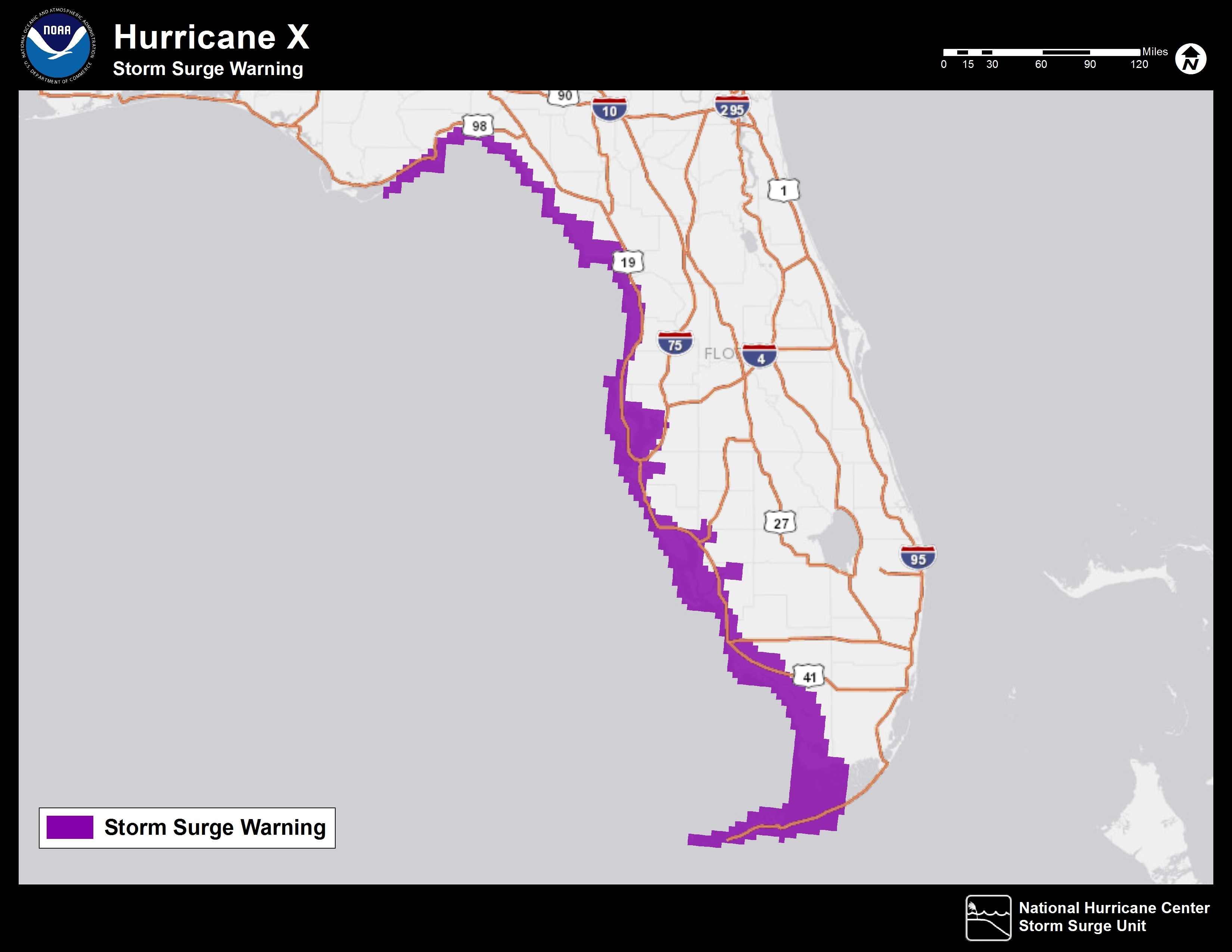
How EFFECTIVE do you think a map like this would be in showing the GENERAL AREA UNDER STORM SURGE WARNING?
EXTREMELY EFFECTIVE
VERY EFFECTIVE
EFFECTIVE
SOMEWHAT EFFECTIVE
NOT EFFECTIVE AT ALL
Do you have any suggestions for improving it?
[OPEN-ENDED RESPONSE]
COASTAL FLOODING MAPS
To help you understand your danger from coastal flooding or STORM SURGE, the National Hurricane Center (NHC) is developing coastal flooding maps for each storm. We are looking for the best way to LABEL these maps so people understand. The maps will show an ESTIMATE OF THE AMOUNT OF OCEAN WATER EXPECTED ON TOP OF THE LAND. The elevation or height of the land above the sea level will already have been subtracted from this estimate.
Please tell us how CLEAR OR EASY TO UNDERSTAND you think each of these LABELS would be.
LABEL |
NOT CLEAR |
SOMEWHAT CLEAR |
VERY CLEAR |
FEET ABOVE GROUND LEVEL |
|
|
|
FEET ABOVE GROUND |
|
|
|
FEET ABOVE ELEVATION |
|
|
|
DEPTH OF WATER |
|
|
|
HEIGHT OF WATER |
|
|
|
Do you have another label to suggest?
[OPEN-ENDED RESPONSE]
What does the phrase “feet above ground level” mean to you?
[OPEN-ENDED RESPONSE]
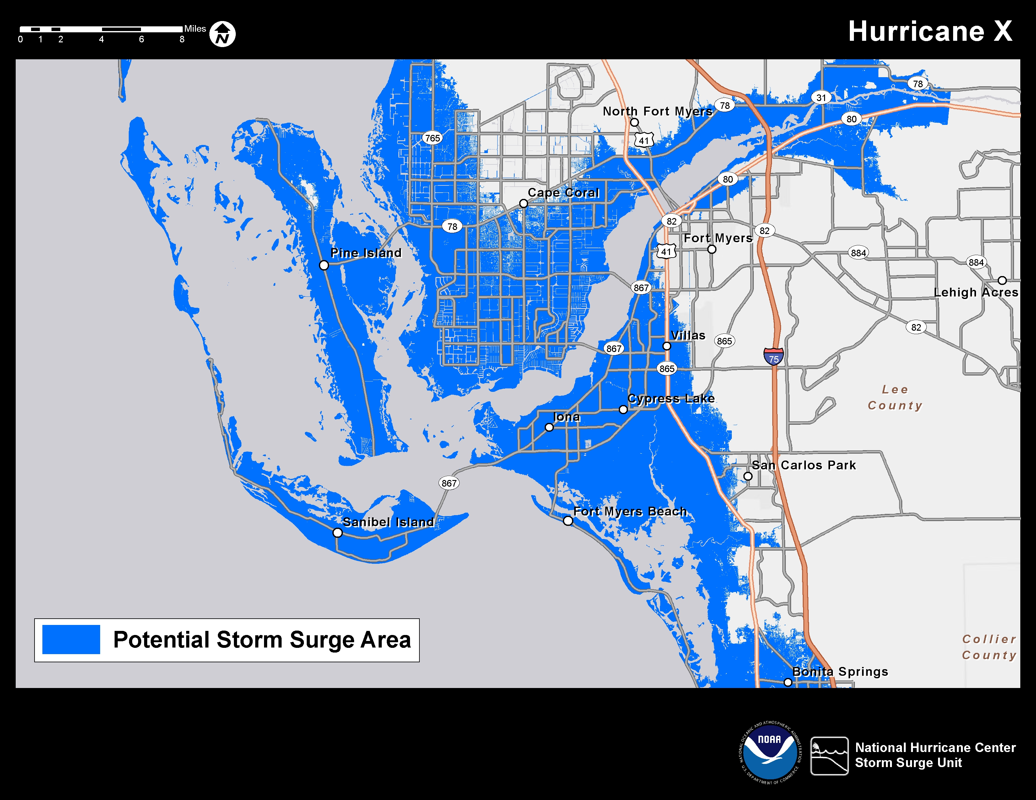
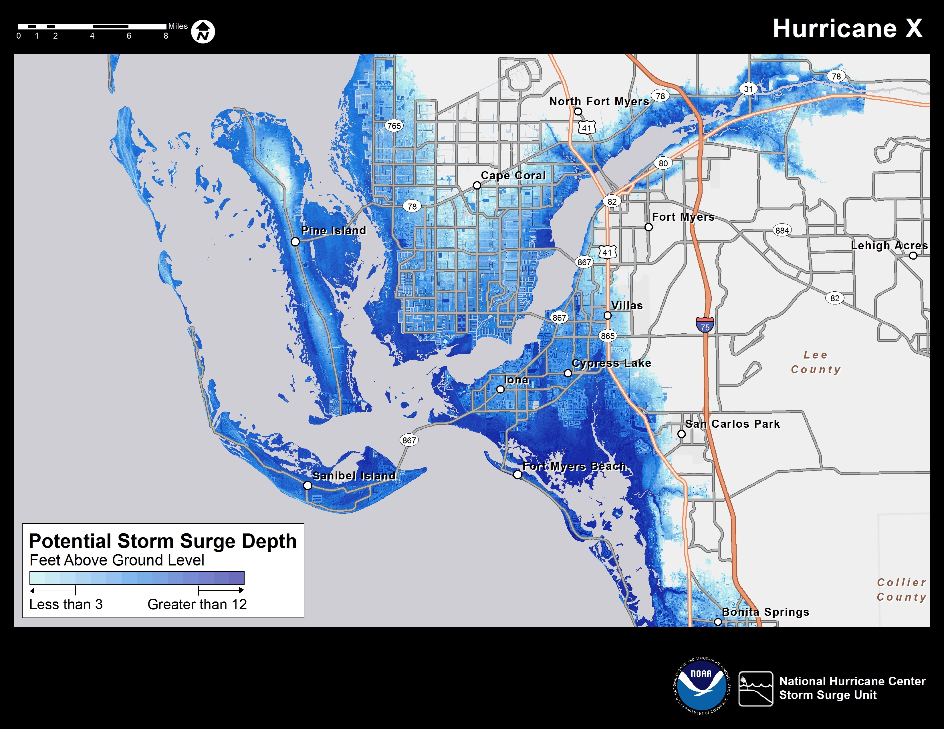
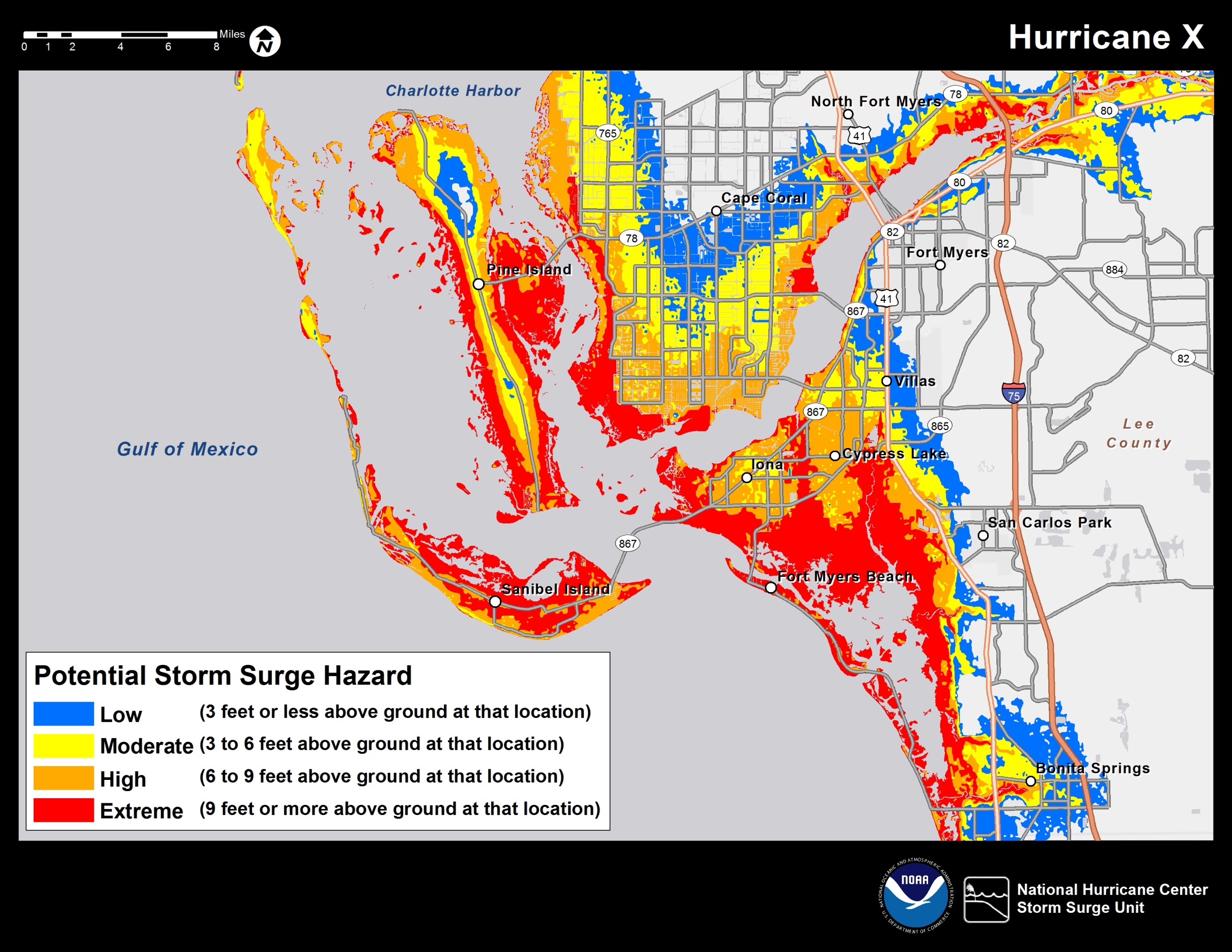
Next you will see three ways this information might be mapped. A past hurricane forecast for Lee County, Florida, is used for the example. (If a storm is forecast where you live, the map will show this information for your area.)
Please STUDY each of next three maps to see what it tells you and then answer the questions to the best of your ability. If you are not sure or don’t know, just choose that option.
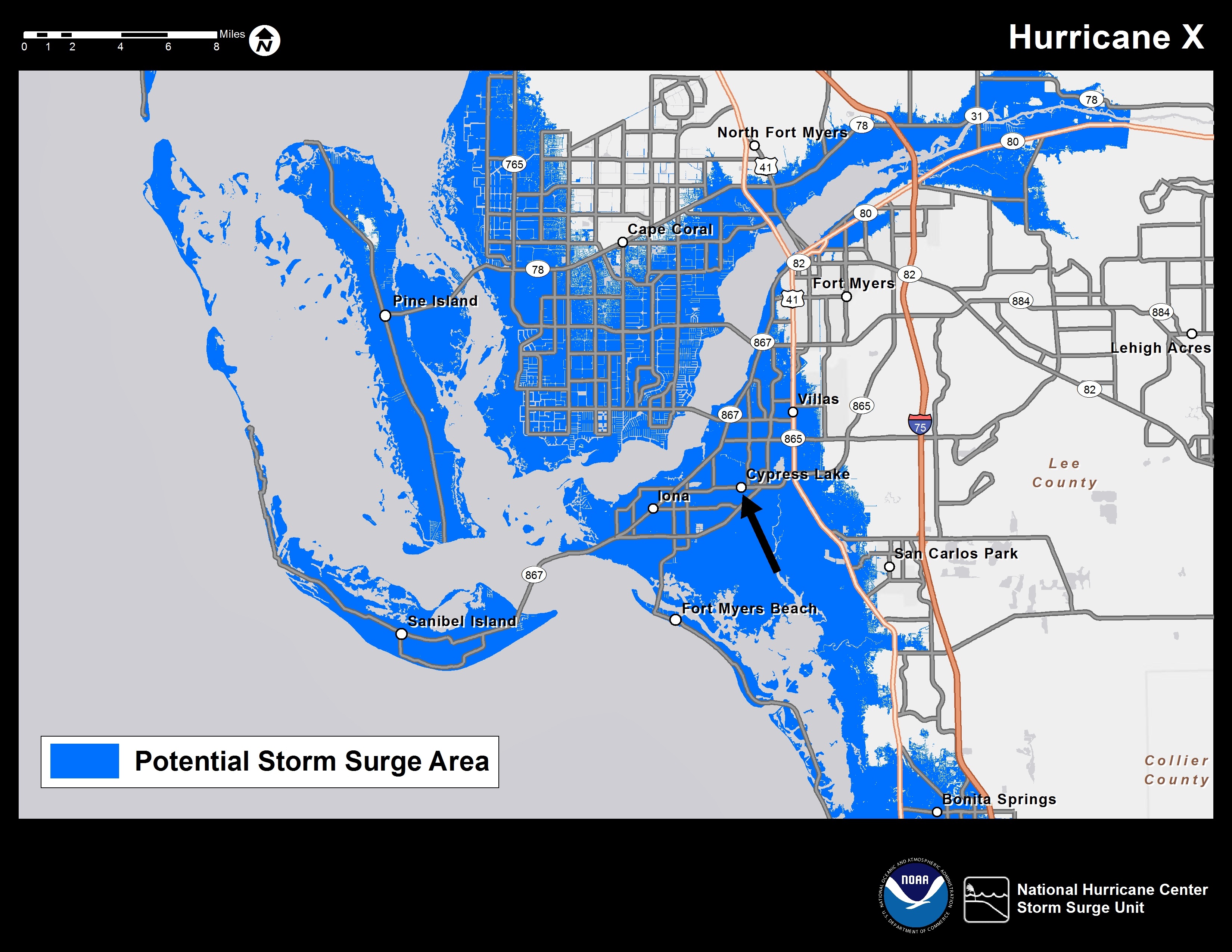
How would you rate this map on EASE OF UNDERSTANDING the surge risk?
EXCELLENT |
VERY GOOD |
GOOD |
FAIR |
POOR |
|
|
|
|
|
Does this map indicate whether you would experience storm surge if you lived at Cypress Lake? (See arrow.)
Yes
No
Cannot Tell
Does this map indicate how DEEP the storm surge might be if you lived at Cypress Lake?
Yes
No
Cannot Tell
Given this information, if you lived in Cypress Lake, would you LEAVE OR EVACUATE your home ahead of this storm?
DEFINITELY WOULD |
PROBABLY WOULD |
PROBABLY WOULD NOT |
DEFINITELY WOULD NOT |
NOT ENOUGH INFORMATION TO DECIDE |
|
|
|
|
|
|
|
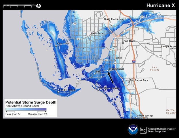
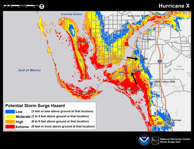
How would you rate this map on EASE OF UNDERSTANDING the surge risk?
EXCELLENT |
VERY GOOD |
GOOD |
FAIR |
POOR |
|
|
|
|
|
How much flooding does this third map estimate for Cypress Lake?
Less Than 3 Feet
3 to 6 Feet
6 to 9 Feet
Not Sure/Don’t Know
If you lived there, given this information, how likely is it that you would LEAVE your home ahead of this storm?
If you lived in the Villas, how likely is it that you would LEAVE your home ahead of this storm?DEFINITELY WOULD
PROBABLY WOULD
PROBABLY WOULD NOT
DEFINITELY WOULD NOT
NOT ENOUGH INFORMATION TO DECIDE
DEFINITELY WOULD |
PROBABLY WOULD |
PROBABLY WOULD NOT |
DEFINITELY WOULD NOT |
NOT ENOUGH INFORMATION TO DECIDE |
|
|
|
|
|
|
|
Map
2
Map
1

Map
3
Of these three maps, which ONE do you think does the BEST JOB of telling you what to expect?
Map #1: One Shade of Blue Shows Entire Area Under Surge Threat
Map #2: Shades of Blue Show Range of Potential Storm Surge Depth
Map #3: Colors Show Four Levels With Potential Range of Surge Depth for Each
Thinking about the one you choose, how would you rate it on these qualities?
|
EXCELLENT |
VERY GOOD |
GOOD |
FAIR |
POOR |
EASY TO UNDERSTAND |
|
|
|
|
|
PROVIDES USEFUL INFORMATION |
|
|
|
|
|
COMMUNICATES THE RISK |
|
|
|
|
|
PROMOTES PROTECTIVE ACTION |
|
|
|
|
|
TROPICAL STORM FORECAST CONE
The following map has a “Forecast Cone” that indicates the likely path of this storm. Based on past forecast error, the forecasters expect the eye of the storm to stay within the Cone about two-thirds of the time.
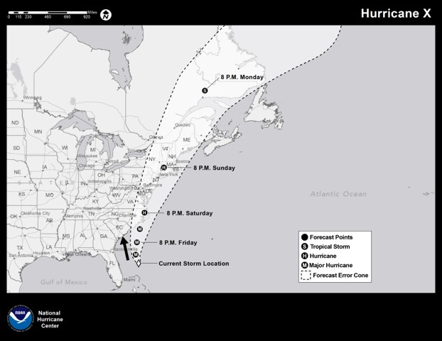
How would you rate this graphic on EASE OF UNDERSTANDING the forecast path and timing?
EXCELLENT |
VERY GOOD |
GOOD |
FAIR |
POOR |
|
|
|
|
|
How would you rate this map on providing what people need to know?
EXCELLENT |
VERY GOOD |
GOOD |
FAIR |
POOR |
|
|
|
|
|
Looking at this map, if you lived in coastal SOUTH CAROLINA (SC), how likely do you think it is that you WOULD BE AFFECTED by this hurricane?
DEFINITELY WOULD |
PROBABLY WOULD |
PROBABLY WOULD NOT |
DEFINITELY WOULD NOT |
NOT SURE/ DON’T KNOW |
|
|
|
|
|
|
|
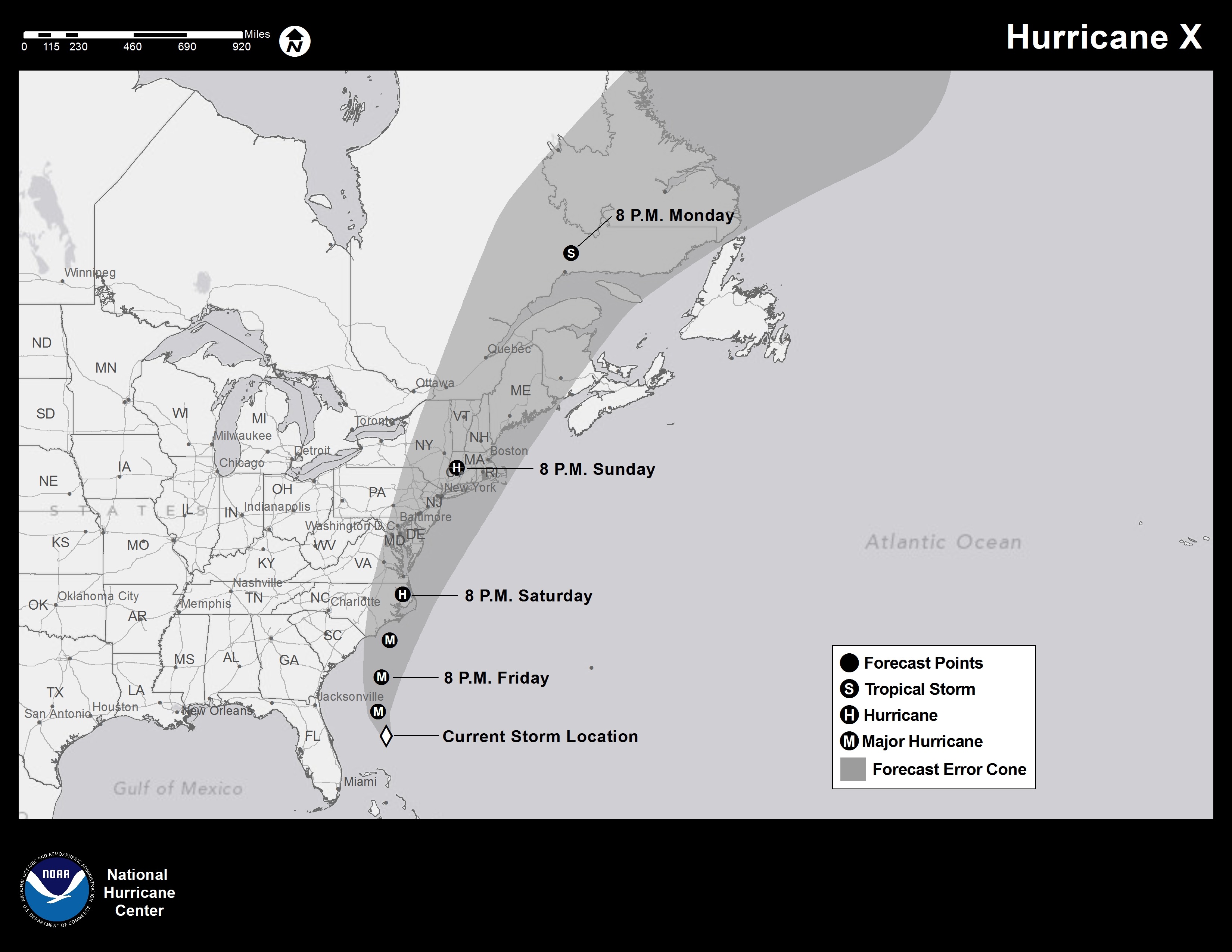
How would you rate this graphic on EASE OF UNDERSTANDING the forecast path and timing?
EXCELLENT |
VERY GOOD |
GOOD |
FAIR |
POOR |
|
|
|
|
|
How would you rate this map on providing what people need to know?
EXCELLENT |
VERY GOOD |
GOOD |
FAIR |
POOR |
|
|
|
|
|
POTENTIAL FOR DAMAGING WINDS
The next map shows areas that may get damaging winds from the same storm.
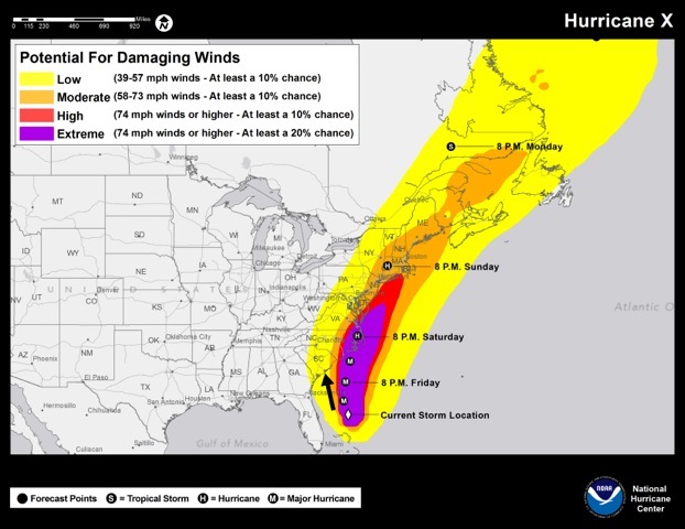
How would you rate this map on EASE OF UNDERSTANDING the wind risk?
EXCELLENT |
VERY GOOD |
GOOD |
FAIR |
POOR |
|
|
|
|
|
How would you rate this map on USEFULNESS, that is, providing what people need to know about whether they may get damaging winds?
EXCELLENT |
VERY GOOD |
GOOD |
FAIR |
POOR |
|
|
|
|
|
Looking at this map, if you lived in coastal SOUTH CAROLINA (SC), how likely is it that you would get damaging winds?
DEFINITELY WOULD |
PROBABLY WOULD |
PROBABLY WOULD NOT |
DEFINITELY WOULD NOT |
NOT SURE/ DON’T KNOW |
|
|
|
|
|
|
|
WIND PLUS CONE
Please study the next map that combines the previous Forecast Cone and wind graphic.
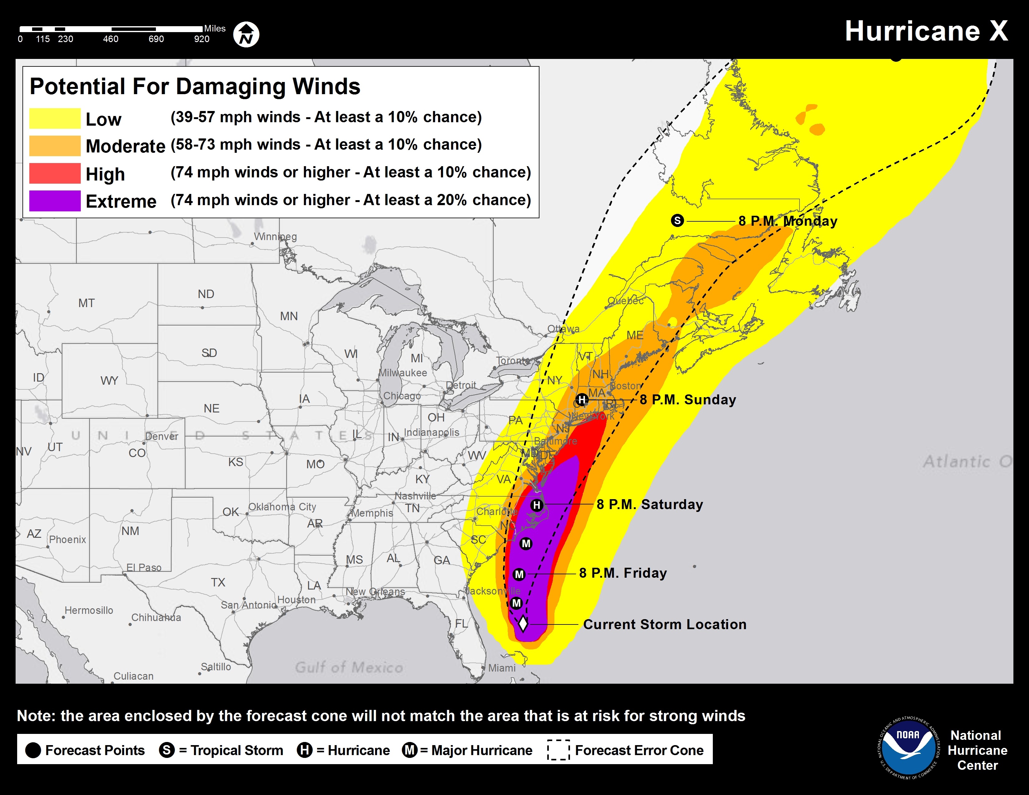
How would you rate this map on EASE OF UNDERSTANDING the path and wind information?
EXCELLENT |
VERY GOOD |
GOOD |
FAIR |
POOR |
|
|
|
|
|
Does this map give you information on each of these topics?
TYPE OF INFORMATION |
YES |
NO |
NOT SURE/ DON’T KNOW |
POSSIBLE TRACK OF STORM |
|
|
|
STORM SURGE |
|
|
|
WHETHER A TROPICAL STORM OR A HURRICANE |
|
|
|
WIND |
|
|
|
WHEN CENTER LIKELY TO ARRIVE |
|
|
|
This next graphic also combines the track and wind information, but this time displays the wind information for only the land area.
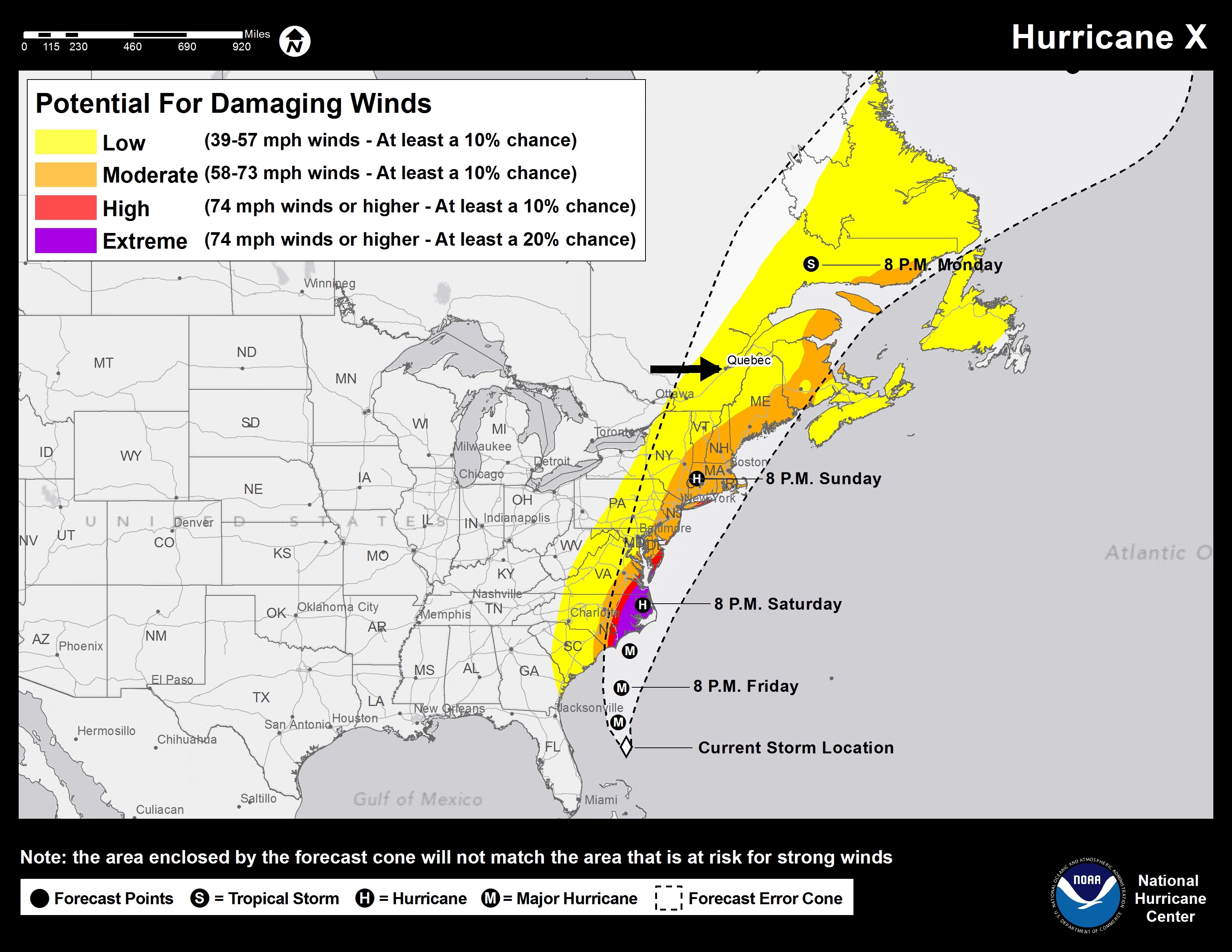
How would you rate this map on EASE OF UNDERSTANDING?
EXCELLENT |
VERY GOOD |
GOOD |
FAIR |
POOR |
|
|
|
|
|
How would you rate this map on USEFULNESS, that is, providing what people need to know about whether they may get damaging winds?
EXCELLENT |
VERY GOOD |
GOOD |
FAIR |
POOR |
|
|
|
|
|
If you lived in Quebec, Canada, how would you interpret your risk based on this map?
The Eye of This Hurricane Is Going to Go Over My Area Sometime Monday
There Is a Good Chance This Hurricane Will Affect My Weather Sometime Monday
The Storm Is Too Far Away for This Map to Provide Any Useful Information
None of the Above
Not Sure/Don’t Know


The areas that are likely to be most affected by this storm are coastal North Carolina and Virginia. Which map do you think BEST COMMUNICATES THE URGENCY to those areas?
Map #1 that Shows the Information Over Land and Water
Map #2 that Shows the Information Only Over Land
Not Sure/Don’t Know
ARRIVAL OF TROPICAL STORM FORCE WINDS
Emergency managers and others have asked for information about WHEN TO EXPECT THE ARRIVAL of tropical storm force winds. TROPICAL STORM FORCE WINDS are winds that stay at 39 miles per hour or higher for at least one minute. All preparations should be completed by the time such winds arrive; after they do, it is dangerous to be outside or on the roads.
The following map shows the approximate arrival times for tropical storm force winds for areas on the East Coast.
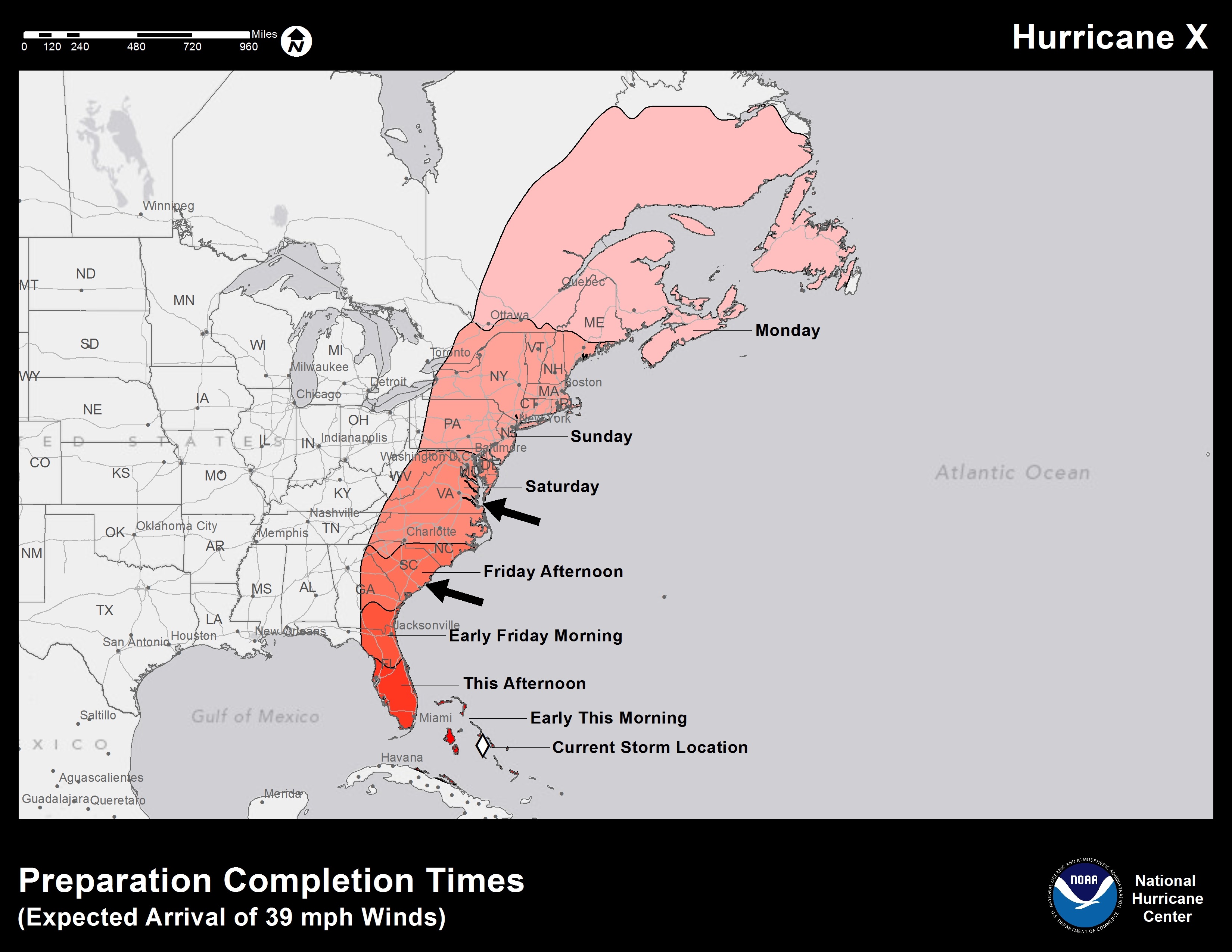
How would you rate this map on EASE OF UNDERSTANDING when to expect tropical storm force winds?
EXCELLENT |
VERY GOOD |
GOOD |
FAIR |
POOR |
|
|
|
|
|
How would you rate this map on USEFULNESS, that is, providing the information people need?
EXCELLENT |
VERY GOOD |
GOOD |
FAIR |
POOR |
|
|
|
|
|
If you lived in coastal SOUTH CAROLINA, when would you be likely to get the first tropical force winds? That is, when should you be ready for the storm?
Friday Afternoon
Early Friday Morning
Sometime Saturday
Not Sure/Don’t Know
If you lived in coastal VIRGINIA, when would you be likely to get the first tropical force winds? That is, when should you be ready for the storm?
Friday Afternoon
Early Friday Morning
Sometime Saturday
Not Sure/Don’t Know
HURRICANE RESPONSE AND EXPERIENCE
If a major hurricane, Category 3 or above, threatens your area, how likely is it that you will EVACUATE OR LEAVE your home ahead of the storm?
DEFINITELY WOULD |
PROBABLY WOULD |
MAYBE |
PROBABLY WOULD NOT |
DEFINITELY WOULD NOT |
|
|
|
|
|
|
|
What about for a Category 1 or 2 hurricane? How likely is it that you will EVACUATE OR LEAVE your home?
Have you EVER evacuated for a severe coastal storm or a hurricane?DEFINITELY WOULD
PROBABLY WOULD
MAYBE
PROBABLY WOULD NOT
DEFINITELY WOULD NOT
Yes
No
If a hurricane or severe coastal storm threatens your area, you will need information. How much do you think you would use each of the following SOURCES FOR YOUR FORECAST INFORMATION?
INFORMATION SOURCE |
NEVER |
SOME |
A LOT |
THE MOST |
LOCAL TV NEWS |
|
|
|
|
NATIONAL TV NEWS (E.G., ABC, CBS, NBC, CNN, OR FOX) |
|
|
|
|
WEATHER CHANNEL ON TV |
|
|
|
|
LOCAL RADIO STATION |
|
|
|
|
NOAA WEATHER RADIO |
|
|
|
|
FRIENDS OR FAMILY |
|
|
|
|
INTERNET |
|
|
|
|
Are there any other sources you would use that you’d like to mention?
[OPEN-ENDED RESPONSE]
If you will get SOME OF YOUR INFORMATION BEFORE THE STORM ON THE INTERNET, how much will you probably use each of these WEBSITES for hurricane information?
Please don’t answer if you do not use the Internet for weather or storm information.
WEBSITE |
NEVER |
SOME |
A LOT |
THE MOST |
LOCAL TV NEWS |
|
|
|
|
NATIONAL TV NEWS |
|
|
|
|
NATIONAL HURRICANE CENTER |
|
|
|
|
LOCAL OFFICE OF WEATHER SERVICE |
|
|
|
|
OTHER NOAA WEBSITE |
|
|
|
|
WEATHER CHANNEL |
|
|
|
|
WEATHER UNDERGROUND |
|
|
|
|
OTHER WEATHER WEBSITE |
|
|
|
|
LOCAL EMERGENCY MANAGEMENT |
|
|
|
|
Are there any other websites you’d like to mention?
[OPEN-ENDED RESPONSE]
How much would you probably use each of these devices TO GET TO THE INTERNET?
|
NOT AT ALL |
SOME |
A LOT |
THE MOST |
MOBILE DEVICE SUCH AS SMART PHONE OR PAD |
|
|
|
|
COMPUTER IN MY HOME |
|
|
|
|
COMPUTER AT WORK |
|
|
|
|
COMPUTER AT A PUBLIC PLACE |
|
|
|
|
OTHER: SPECIFY |
|
|
|
|
Are you familiar with the services and information offered by the National Weather Service (NWS) office LOCATED IN YOUR AREA?
Yes
No
Not Sure/Don’t Know
In what TOWN OR CITY is the NWS office for your area located?
_____________
Not sure/Don’t Know
How much do you use the WEBSITE OF THE LOCAL NATIONAL WEATHER SERVICE OFFICE to get weather information?
NEVER |
A LITTLE |
SOME |
A LOT |
|
|
|
|
If you live in an area affected by tropical storms, how much do you use the website of the National Hurricane Center when a tropical storm threatens your area?
NEVER |
A LITTLE |
SOME |
A LOT |
|
|
|
|
DEMOGRAPHICS
To make sure NWS products meet the needs of many types of users, we need to know a little about you. Your answers will not be linked to you but they will help us understand the needs of people like you. You can, of course, decide not to answer any question.
What is your ZIP code? (Please answer, as this helps us understand your answers in relation to how far you live from the coastline.) ____________
What TYPE OF HOUSE do you live in?
Single Family Home
Apartment or Condominium
Mobile Home or Manufactured Housing
Town House
Other (Specify: _______________)
About how OLD are you?
21-25
26-40
41-60
61-75
76 or older
What is the HIGHEST EDUCATION you have received?
Grade School
Some High School
High School Graduate
Vocational/Technical
Some College
College Graduate
Graduate Degree
Are you male or female?
Female
Male
Do you consider yourself to be HISPANIC OR LATINO?
Yes
No
Not Sure/Don’t Know
How would you describe your RACE? You may give multiple answers.
White
Black or African American
American Indian or Alaska Native
Asian
Native Hawaiian or Other Pacific Islander
Other
Not Sure/Don’t Know
What is the MAIN LANGUAGE spoken in your home?
ENGLISH
SPANISH
Other (Specify: _______________)
About HOW MUCH MONEY DID YOUR WHOLE HOUSEHOLD TOGETHER MAKE LAST YEAR?
$10,000 or Less
Between $10,000 and $20,000
Between $20,000 and $30,000
Between $30,000 and $50,000
Between $50,000 and $80,000
Between $80,000 and $100,000
Over $100,000
Don’t Know/No Response
Do you have any comments that you would like to make about this survey or about the topics mentioned?
[OPEN-ENDED RESPONSE]
Thank you for completing this survey to help your National Weather Service improve its coastal storm services!
1 The National Weather Service is the official weather forecasting service for the United States. It consists of several centers, such as the National Hurricane Center, and regional forecast offices around the country, such as the Miami-South Florida Weather Forecast Office.
2 A type of cyclone that occurs outside the tropics in the middle latitudes.
| File Type | application/vnd.openxmlformats-officedocument.wordprocessingml.document |
| Author | lazo |
| File Modified | 0000-00-00 |
| File Created | 2021-01-31 |
© 2026 OMB.report | Privacy Policy